RESULTS FOR GRID SQUARE 66d
MAPS FOR GRID SQUARE 66d
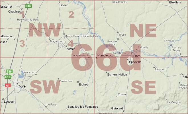
Map Location Diagram
- The Map Location Diagram (right) shows the relative position of places within the area of this grid square.
- Maps having this Map Reference Number will cover the whole area but be less detailed.
- Maps with NE, NW, SE or SW in the Map Reference Number will only cover one-quarter of the whole area but be more detailed.
- Click the following links for more information about How to Read a Map Reference Number or about Map Scale.
Maps for Grid Square 66d
| Link to Image | Map Sheet Number | Scale | Area | Date |
|---|---|---|---|---|
|
392WW1MAP |
62d SE, 62c SW, 66e NE, 66d NW | 1:40,000 | Meharicourt | 1915 |
|
338WW1MAP |
62d SE, 62c SW, 66e NE, 66d NW (parts) | 1:20,000 | Hattencourt | 1918/08 |
|
164WW1MAP |
62d SE, 62c SW, 66e NE, 66d NW, 66e SE, 66d SW (pa | 1:20,000 | Hattencourt | 1918/08 |
|
395WW1MAP |
66d | 1:40,000 | Ham | 1917/11 |
|
59WW1MAP |
66d | 1:40,000 | Ham | 1917/11 |
|
PC0740WW1MAP |
66d | 1:40,000 | Nesle - Roye | 1918/06 |
|
103WW1MAP |
66d NW | 1:20,000 | Chaulnes | 1917/01 |
|
PC0472WW1MAP |
66d NW | 1:20,000 | Chaulnes - Hallu | 1917/01 |
|
345WW1MAP |
66d NW | 1:20,000 | Fresnoy-Les-Roye | 1918/08 |
|
PC0187WW1MAP |
66d NW1 | 1:10,000 | Lihons - Bersaucourt | 1917/03 |
|
PC0188WW1MAP |
66d NW3 | 1:10,000 | Fransart - Rethonvillers | 1917/03 |
|
PC0474WW1MAP |
66e NE & 66d NW (Parts of) | 1:20,000 | Caix - Vrely | 1917/01 |
|
PC0475WW1MAP |
66e NE & 66d NW (Parts of) | 1:20,000 | Caix - Vrely | 1917/01 |
AERIAL PHOTOGRAPHS FOR GRID SQUARE 66d
There are no aerial photographs in our collection for this area
Contact: mapref@mcmaster.ca