RESULTS FOR GRID SQUARE 62d
MAPS FOR GRID SQUARE 62d
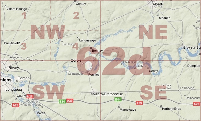
Map Location Diagram
- The Map Location Diagram (right) shows the relative position of places within the area of this grid square.
- Maps having this Map Reference Number will cover the whole area but be less detailed.
- Maps with NE, NW, SE or SW in the Map Reference Number will only cover one-quarter of the whole area but be more detailed.
- Click the following links for more information about How to Read a Map Reference Number or about Map Scale.
Maps for Grid Square 62d
| Link to Image | Map Sheet Number | Scale | Area | Date |
|---|---|---|---|---|
|
32WW1MAP |
57d SE, 57c SW, 62d NE, 62c NW | 1:20,000 | Mametz | 1916 |
|
144WW1MAP |
57d SW, 57d SE, 62d NW, 62d NE (parts) | 1:20,000 | Senlis | |
|
58WW1MAP |
62d | 1:40,000 | Corbie | 1916 |
|
393WW1MAP |
62d | 1:40,000 | Corbie | 1918/05 |
|
100WW1MAP |
62d NE | 1:20,000 | Mametz | 1915 |
|
99WW1MAP |
62d NE | 1:20,000 | Mametz | 1916 |
|
PC0464WW1MAP |
62d NE | 1:20,000 | Millencourt - Lavierville | 1916/00 |
|
97WW1MAP |
62d NE | 1:20,000 | Mametz | 1916 |
|
PC0465WW1MAP |
62d NE | 1:20,000 | Millencourt - Lavierville | 1916/00 |
|
PC0466WW1MAP |
62d NE | 1:20,000 | Millencourt - Lavierville | 1916/00 |
|
PC0180WW1MAP |
62d NE2 | 1:10,000 | Albert - Bronfay Farm | 1916/00 |
|
PC0180WW1MAP |
62d NE2 | 1:10,000 | Albert - Bronfay Farm | 1916/00 |
|
PC0180WW1MAP |
62d NE2 | 1:10,000 | Albert - Bronfay Farm | 1916/00 |
|
PC0181WW1MAP |
62d NE2 | 1:10,000 | Albert - Bronfay Farm | 1916/00 |
|
PC0182WW1MAP |
62d NE2 | 1:10,000 | Albert - Bronfay Farm | 1916/00 |
|
341WW1MAP |
62d SE | 1:20,000 | Harbonnieres | 1918/07 |
|
PC0467WW1MAP |
62d SE | 1:20,000 | Hamel - Ignaucourt | 1918/07 |
|
392WW1MAP |
62d SE, 62c SW, 66e NE, 66d NW | 1:40,000 | Meharicourt | 1915 |
|
338WW1MAP |
62d SE, 62c SW, 66e NE, 66d NW (parts) | 1:20,000 | Hattencourt | 1918/08 |
|
164WW1MAP |
62d SE, 62c SW, 66e NE, 66d NW, 66e SE, 66d SW (pa | 1:20,000 | Hattencourt | 1918/08 |
|
PC0183WW1MAP |
62d SE4 & 62c SW3 | 1:10,000 | River Somme - Belloy | 1915/00 |
|
163WW1MAP |
62d SE4, 62c SW3 (parts) | 1:10,000 | Ablaincourt | 1915 |
|
342WW1MAP |
62d SW | 1:20,000 | Boves | 1918/07 |
|
333WW1MAP |
62d SW, 62d SE, 66e NW, 66e NE (parts) | 1:20,000 | Caix | 1918/07 |
|
463WW1MAP |
62dSE | 1:20,000 | Harbonnieres | 1918/07 |
|
PC0713WW1MAP |
Parts of 57d SE, 62d NE | 1:20,000 | Bouzincourt - Ville-sur-Ancrew | 1918/04 |
|
PC0714WW1MAP |
Parts of 62d NE, 62d SE | 1:20,000 | Morlancourt - R. Somme | 1918/08 |
|
PC0705WW1MAP |
Parts of Sheet 57d SEm 57c SWm 62d NE, 62c NW | 1:20,000 | Ovillers-la-Boisselle - Maurepas Station | 1916 |
|
PC0855WW1MAP |
Parts of Sheets 57d SE, 57c SW, 62d NE, 62c NW | 1:20,000 | Ovillers-la-Boisselle - Maurepas Station | 1916 |
|
PC0856WW1MAP |
Parts of Sheets 57d SE, 57c SW, 62d NE, 62c NW | 1:20,000 | Ovillers-la-Boisselle - Maurepas Station | 1916 |
|
PC0857WW1MAP |
Parts of Sheets 57d SE, 57c SW, 62d NE, 62c NW | 1:20,000 | Ovillers-la-Boisselle - Maurepas Station | 1916 |
AERIAL PHOTOGRAPHS FOR GRID SQUARE 62d
Aerial Photograph Location Diagram
- Consult the lettered grid (below) in conjuction with the place names on the map location diagram (lower right) to determine which lettered squares cover your area of interest.
- Choose aerial photos in the table below which have those letters directly following the grid square number.
- Click the following link for more information on How to Read an Aerial Photograph Number.
Map Location Diagram

Aerial Photographs for Grid Square 62d
| Link to Image | Map Reference Number | Area | Year | Month | Day |
|---|---|---|---|---|---|
|
515WW1AIR |
62d.E.24.d. | Fricourt; Becordel; Meaulte. | 1918 | 8 | 9 |
|
514WW1AIR |
62d.E.24.d. | Fricourt; Becordel; Meaulte. | 1918 | 8 | 9 |
|
513WW1AIR |
62d.E.F.L.R. | Fricourt; Bray-sur-Somme; Mericourt; Erinehem. | 1918 | 8 | 9 |
|
516WW1AIR |
62d.F.19.d.25.c. | Fricourt. | 1918 | 8 | 9 |
|
532WW1AIR |
62d.K.35.d.36.b. | Somme Canal; Cateaux Wood. | 1918 | 8 | 10 |
|
517WW1AIR |
62d.L.1. | 1917 | 8 | 9 | |
|
518WW1AIR |
62d.L.1.a. | 1918 | 8 | 9 | |
|
522WW1AIR |
62d.L.13 | Bray-sur-Somme; Yakko Copse. | 1918 | 8 | 9 |
|
523WW1AIR |
62d.L.19.b. | Bray-sur-Somme. | 1918 | 8 | 9 |
|
524WW1AIR |
62d.L.19.d.8.5. | Bray-sur-Somme. | 1918 | 8 | 9 |
|
525WW1AIR |
62d.L.25.b. | Erinehem; Yakko Copse. | 1918 | 8 | 9 |
|
527WW1AIR |
62d.L.31.a. | Garenne Wood. | 1918 | 8 | 9 |
|
526WW1AIR |
62d.L.32.a. | Erinehem. | 1918 | 8 | 9 |
|
520WW1AIR |
62d.L.8.a. | Ceylon Wood. | 1918 | 7 | 9 |
|
521WW1AIR |
62d.L.8.b.9.c.11.c. | Bray-sur-Somme | 1918 | 8 | 9 |
|
529WW1AIR |
62d.Q. | Mericourt; Somme Canal; Cateaux Wood. | 1918 | 8 | 10 |
|
531WW1AIR |
62d.Q.12.R.7. | Mericourt; Coreaux Wood | 1918 | 8 | 10 |
|
528WW1AIR |
62d.Q.6.b. | Mericourt; Chuignoles. | 1918 | 8 | 9 |
|
530WW1AIR |
62d.Q.6.d | Mericourt; Somme Canal. | 1918 | 8 | 10 |
Contact: mapref@mcmaster.ca