RESULTS FOR GRID SQUARE 62c
MAPS FOR GRID SQUARE 62c
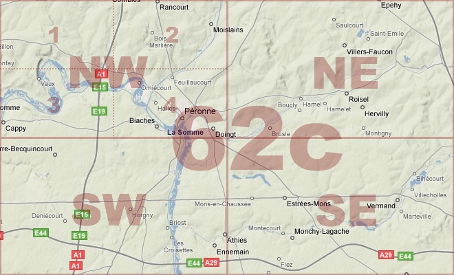
Map Location Diagram
- The Map Location Diagram (right) shows the relative position of places within the area of this grid square.
- Maps having this Map Reference Number will cover the whole area but be less detailed.
- Maps with NE, NW, SE or SW in the Map Reference Number will only cover one-quarter of the whole area but be more detailed.
- Click the following links for more information about How to Read a Map Reference Number or about Map Scale.
Maps for Grid Square 62c
| Link to Image | Map Sheet Number | Scale | Area | Date |
|---|---|---|---|---|
|
192WW1MAP |
57c SE, 57b SW, 62c NE, 62b NW (parts) | 1:20,000 | Wiancourt | 1918/09 |
|
152WW1MAP |
57c SE, 57b SW, 62c NE, 62b NW (parts) | 1:20,000 | St. Emilie | |
|
32WW1MAP |
57d SE, 57c SW, 62d NE, 62c NW | 1:20,000 | Mametz | 1916 |
|
391WW1MAP |
62c | 1:40,000 | Peronne | 1917/12 |
|
57WW1MAP |
62c | 1:40,000 | Peronne | 1917/12 |
|
69WW1MAP |
62c | 1:40,000 | Peronne | 1917/12 |
|
PC0742WW1MAP |
62c | 1:40,000 | Somme Valley - Savy | 1918/06 |
|
PC0455WW1MAP |
62c NE | 1:20,000 | Nurlu - Longavesnes | 1917/10 |
|
PC0456WW1MAP |
62c NE | 1:20,000 | Nurlu - Longavesnes | 1917/08 |
|
6WW1MAP |
62c NE | 1:20,000 | Nurta | 1917/03 |
|
PC0457WW1MAP |
62c NE | 1:20,000 | Nurlu - Longavesnes | 1917/08 |
|
PC0458WW1MAP |
62c NE | 1:20,000 | Nurlu - Longavesnes | 1917/12 |
|
5WW1MAP |
62c NE | 1:20,000 | Nurta | 1918/08 |
|
83WW1MAP |
62c NE | 1:20,000 | Nurta | 1918/08 |
|
190WW1MAP |
62c NE, 62c SE, 62b NW, 62b SW (parts) | 1:20,000 | Maissemy | 1918/09 |
|
PC0176WW1MAP |
62c NE1 | 1:10,000 | Nurlu - Longavesnes | 1917/03 |
|
126WW1MAP |
62c NEA | 1:10,000 | Hargicourt | 1917/12 |
|
81WW1MAP |
62c NW | 1:20,000 | Peronne | 1915 |
|
95WW1MAP |
62c NW | 1:20,000 | Peronne | 1916 |
|
PC0449WW1MAP |
62c NW | 1:20,000 | Somme River - Cappy | 1916/00 |
|
PC0450WW1MAP |
62c NW | 1:20,000 | Somme River - Cappy | 1916/00 |
|
PC0451WW1MAP |
62c NW | 1:20,000 | Somme River - Cappy | 1916/00 |
|
PC0452WW1MAP |
62c NW | 1:20,000 | Somme River - Cappy | 1917/01 |
|
86WW1MAP |
62c NW | 1:20,000 | Peronne | 1918/08 |
|
PC0453WW1MAP |
62c NW | 1:20,000 | Somme River - Cappy | 1918/03 |
|
PC0454WW1MAP |
62c NW | 1:20,000 | Somme River - Cappy | 1918/08 |
|
PC0169WW1MAP |
62c NW1 | 1:10,000 | Carnoy - Hem Station | 1915/00 |
|
PC0170WW1MAP |
62c NW1 | 1:10,000 | Carnoy - Hem Station | 1916/00 |
|
PC0171WW1MAP |
62c NW1 | 1:10,000 | Carnoy - Hem Station | 1916/00 |
|
159WW1MAP |
62c NW1 | 1:10,000 | Maricourt | 1915 |
|
PC0172WW1MAP |
62c NW2 | 1:10,000 | Rancourt - Canal du Nord | 1916/00 |
|
PC0173WW1MAP |
62c NW2 | 1:10,000 | Rancourt - Canal du Nord | 1917/01 |
|
PC0174WW1MAP |
62c NW3 | 1:10,000 | Suzanne - Flaucourt | 1916/00 |
|
37WW1MAP |
62c NW3 | 1:10,000 | Calais | 1915 |
|
PC0508WW1MAP |
62c NW4 | 1:5,000 | ||
|
PC0175WW1MAP |
62c NW4 | 1:10,000 | Clery-sur-Somme - Doingt | 1916/00 |
|
PC0460WW1MAP |
62c SE | 1:20,000 | Cartigny - Bouvincourt | 1917/02 |
|
PC0461WW1MAP |
62c SE | 1:20,000 | Cartigny - Bouvincourt | 1917/02 |
|
PC0462WW1MAP |
62c SE | 1:20,000 | Cartigny - Bouvincourt | 1918/03 |
|
PC0463WW1MAP |
62c SE | 1:20,000 | Cartigny - Bouvincourt | 1918/03 |
|
354WW1MAP |
62c SW | 1:20,000 | Barleux | 1917/03 |
|
PC0459WW1MAP |
62c SW | 1:20,000 | Dompierre - Athies | 1918/08 |
|
111WW1MAP |
62c SW1 | 1:10,000 | Becquincourt | 1917/01 |
|
160WW1MAP |
62c SW1 | 1:10,000 | Becquincourt | 1915 |
|
PC0177WW1MAP |
62c SW1 & 2 (parts) | 1:10,000 | River Somme - Peronne | 1917/01 |
|
PC0178WW1MAP |
62c SW3 | 1:10,000 | River Somme - Belloy | 1917/01 |
|
PC0179WW1MAP |
62c SW3 & 4 (parts) | 1:10,000 | River Somme - Belloy | 1917/01 |
|
392WW1MAP |
62d SE, 62c SW, 66e NE, 66d NW | 1:40,000 | Meharicourt | 1915 |
|
338WW1MAP |
62d SE, 62c SW, 66e NE, 66d NW (parts) | 1:20,000 | Hattencourt | 1918/08 |
|
164WW1MAP |
62d SE, 62c SW, 66e NE, 66d NW, 66e SE, 66d SW (pa | 1:20,000 | Hattencourt | 1918/08 |
|
PC0183WW1MAP |
62d SE4 & 62c SW3 | 1:10,000 | River Somme - Belloy | 1915/00 |
|
163WW1MAP |
62d SE4, 62c SW3 (parts) | 1:10,000 | Ablaincourt | 1915 |
|
PC0705WW1MAP |
Parts of Sheet 57d SEm 57c SWm 62d NE, 62c NW | 1:20,000 | Ovillers-la-Boisselle - Maurepas Station | 1916 |
|
PC0855WW1MAP |
Parts of Sheets 57d SE, 57c SW, 62d NE, 62c NW | 1:20,000 | Ovillers-la-Boisselle - Maurepas Station | 1916 |
|
PC0856WW1MAP |
Parts of Sheets 57d SE, 57c SW, 62d NE, 62c NW | 1:20,000 | Ovillers-la-Boisselle - Maurepas Station | 1916 |
|
PC0857WW1MAP |
Parts of Sheets 57d SE, 57c SW, 62d NE, 62c NW | 1:20,000 | Ovillers-la-Boisselle - Maurepas Station | 1916 |
AERIAL PHOTOGRAPHS FOR GRID SQUARE 62c
Aerial Photograph Location Diagram
- Consult the lettered grid (below) in conjuction with the place names on the map location diagram (lower right) to determine which lettered squares cover your area of interest.
- Choose aerial photos in the table below which have those letters directly following the grid square number.
- Click the following link for more information on How to Read an Aerial Photograph Number.
Map Location Diagram

Aerial Photographs for Grid Square 62c
| Link to Image | Map Reference Number | Area | Year | Month | Day |
|---|---|---|---|---|---|
|
519WW1AIR |
62c.A.25.b.62d.L.2.b.c.d. | Billon Wood. | 1918 | 8 | 9 |
Contact: mapref@mcmaster.ca