RESULTS FOR GRID SQUARE 62b
MAPS FOR GRID SQUARE 62b
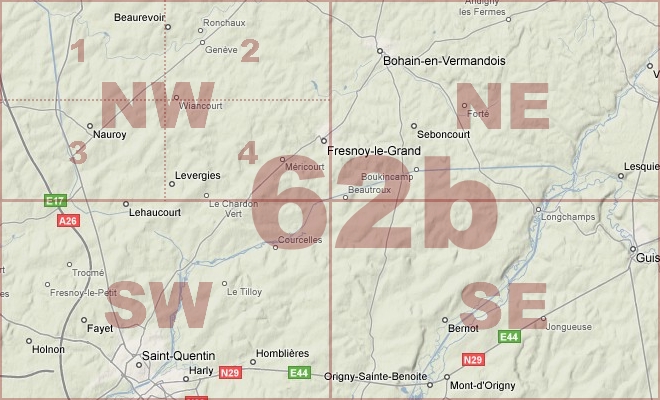
Map Location Diagram
- The Map Location Diagram (right) shows the relative position of places within the area of this grid square.
- Maps having this Map Reference Number will cover the whole area but be less detailed.
- Maps with NE, NW, SE or SW in the Map Reference Number will only cover one-quarter of the whole area but be more detailed.
- Click the following links for more information about How to Read a Map Reference Number or about Map Scale.
Maps for Grid Square 62b
| Link to Image | Map Sheet Number | Scale | Area | Date |
|---|---|---|---|---|
|
192WW1MAP |
57c SE, 57b SW, 62c NE, 62b NW (parts) | 1:20,000 | Wiancourt | 1918/09 |
|
152WW1MAP |
57c SE, 57b SW, 62c NE, 62b NW (parts) | 1:20,000 | St. Emilie | |
|
68WW1MAP |
62b | 1:40,000 | St. Quentin | 1917/12 |
|
172WW1MAP |
62b NE | 1:20,000 | Bohain | 1918/09 |
|
91WW1MAP |
62b NE | 1:20,000 | Bohain | 1918/09 |
|
PC0446WW1MAP |
62b NE | 1:20,000 | Bohain - Etaves | 1918/09 |
|
PC0445WW1MAP |
62b NW | 1:20,000 | Le Catelet - Bony | 1917/12 |
|
82WW1MAP |
62b NW | 1:20,000 | Bellicourt | 1918/03 |
|
105WW1MAP |
62b NW, 62b SW (parts) | 1:20,000 | Bellicourt | 1917/06 |
|
PC0448WW1MAP |
62b SE | 1:20,000 | St. Quentin - Homblieres | 1918/10 |
|
PC0447WW1MAP |
62b SW | 1:20,000 | Pontruet - Marcy | 1918/02 |
|
PC0167WW1MAP |
62b SW1 | 1:10,000 | Hindenburg Line | 07/1917 |
|
PC0168WW1MAP |
62b SW2 | 1:10,000 | east of Gricourt | 1918/02 |
|
190WW1MAP |
62c NE, 62c SE, 62b NW, 62b SW (parts) | 1:20,000 | Maissemy | 1918/09 |
|
PC0842WW1MAP |
Parts of 29, 37, 44, 51, 57, 62b, 66c, 70d | 1:250,000 | SE England Ramsgate - Le Treport | 1918/05 |
AERIAL PHOTOGRAPHS FOR GRID SQUARE 62b
There are no aerial photographs in our collection for this area
Contact: mapref@mcmaster.ca