RESULTS FOR GRID SQUARE 57d
MAPS FOR GRID SQUARE 57d
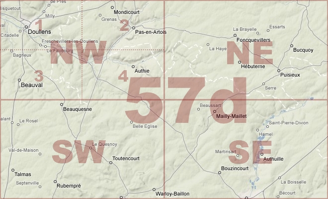
Map Location Diagram
- The Map Location Diagram (right) shows the relative position of places within the area of this grid square.
- Maps having this Map Reference Number will cover the whole area but be less detailed.
- Maps with NE, NW, SE or SW in the Map Reference Number will only cover one-quarter of the whole area but be more detailed.
- Click the following links for more information about How to Read a Map Reference Number or about Map Scale.
Maps for Grid Square 57d
| Link to Image | Map Sheet Number | Scale | Area | Date |
|---|---|---|---|---|
|
PC0357WW1MAP |
51b SW/51c SE/57d NE/57c NW [composite - parts of] | 1:20,000 | Bailleulmont - Pommier | |
|
454WW1MAP |
57d | 1:40,000 | Albert | 1916 |
|
173WW1MAP |
57d | 1:40,000 | Albert | 1917/04 |
|
20WW1MAP |
57d | 1:40,000 | Albert | 1917/04 |
|
21WW1MAP |
57d | 1:40,000 | Albert | 1917/04 |
|
390WW1MAP |
57d | 1:40,000 | Albert | 1917/04 |
|
22WW1MAP |
57d | 1:40,000 | Albert | 1918/03 |
|
PC0439WW1MAP |
57d SE | 1:20,000 | Acheux - Varennes | 1917/02 |
|
80WW1MAP |
57d NE | 1:20,000 | Gommecourt | 1915 |
|
PC0677WW1MAP |
57d NE | 1:20,000 | Monchy-au-Bois - Miraumont | 1916 |
|
PC0416WW1MAP |
57d NE | 1:20,000 | Gaudiempre - Henu | 1916/00 |
|
PC0417WW1MAP |
57d NE | 1:20,000 | Gaudiempre - Henu | 1916/00 |
|
PC0418WW1MAP |
57d NE | 1:20,000 | Gaudiempre - Henu | 1916/00 |
|
74WW1MAP |
57d NE | 1:20,000 | Gommecourt | 1916 |
|
PC0419WW1MAP |
57d NE | 1:20,000 | Gaudiempre - Henu | 1916/00 |
|
PC0420WW1MAP |
57d NE | 1:20,000 | Gaudiempre - Henu | 1916/00 |
|
PC0678WW1MAP |
57d NE | 1:20,000 | Monchy-au-Bois - Miraumont | 1916 |
|
PC0679WW1MAP |
57d NE | 1:20,000 | Monchy-au-Bois - Miraumont | 1916 |
|
PC0680WW1MAP |
57d NE | 1:20,000 | Monchy-au-Bois - Miraumont | 1916/12 |
|
PC0681WW1MAP |
57d NE | 1:20,000 | Monchy-au-Bois - Miraumont | 1916/12 |
|
PC0421WW1MAP |
57d NE | 1:20,000 | Gaudiempre - Henu | 1916/00 |
|
2WW1MAP |
57d NE | 1:20,000 | Gommecourt | 1917/02 |
|
PC0423WW1MAP |
57d NE | 1:20,000 | Gaudiempre - Henu | 1918/03 |
|
210WW1MAP |
57d NE | 1:20,000 | Gommecourt | 1918/05 |
|
PC0424WW1MAP |
57d NE | 1:20,000 | Gaudiempre - Henu | 1918/06 |
|
PC0150WW1MAP |
57d NE1 & 2 | 1:10,000 | Bienvillers-au-Bois - Bucquoy | 1916/00 |
|
PC0151WW1MAP |
57d NE1 & 2 (Parts) | 1:10,000 | Bienvillers-au-Bois - Bucquoy | 1916/00 |
|
128WW1MAP |
57d NE1, 57d NE2 (parts) | 1:10,000 | Gommecourt | 1916 |
|
162WW1MAP |
57d NE1, 57d NE2 (parts) | 1:10,000 | Monchy | 1915 |
|
PC0153WW1MAP |
57d NE3 & 4 (Parts) | 1:10,000 | Gommecourt - Puisieux au Mont | 1915/00 |
|
PC0152WW1MAP |
57d NE3 & 4 (Parts) | 1:10,000 | Gommecourt - Puisieux au Mont | 1915/00 |
|
PC0154WW1MAP |
57d NE3 &4 (Parts) | 1:10,000 | Gommecourt - Puisieux au Mont | 1916/00 |
|
167WW1MAP |
57d NE3, 57d NE4 (parts) | 1:10,000 | Puisieux-au-Mont | 1915 |
|
PC0155WW1MAP |
57d NE4 & 57c NW3 (Parts) | 1:10,000 | Bucquoy - Loupart Wood | 1916/12 |
|
PC0415WW1MAP |
57d NW | 1:20,000 | Doullens - Louvencourt | 1915/07 |
|
102WW1MAP |
57d SE | 1:20,000 | Albert | 1915 |
|
PC0429WW1MAP |
57d SE | 1:20,000 | Acheux - Varennes | 1916/00 |
|
PC0430WW1MAP |
57d SE | 1:20,000 | Acheux - Varennes | 1916/00 |
|
98WW1MAP |
57d SE | 1:20,000 | Albert | 1916 |
|
PC0431WW1MAP |
57d SE | 1:20,000 | Acheux - Varennes | 1916/00 |
|
PC0432WW1MAP |
57d SE | 1:20,000 | Acheux - Varennes | 1916/00 |
|
PC0433WW1MAP |
57d SE | 1:20,000 | Acheux - Varennes | 1916/00 |
|
PC0434WW1MAP |
57d SE | 1:20,000 | Acheux - Varennes | 1916/00 |
|
PC0435WW1MAP |
57d SE | 1:20,000 | Acheux - Varennes | 1916/00 |
|
PC0436WW1MAP |
57d SE | 1:20,000 | Acheux - Varennes | 1916/00 |
|
7WW1MAP |
57d SE | 1:20,000 | Albert | 1916/12 |
|
PC0437WW1MAP |
57d SE | 1:20,000 | Acheux - Varennes | 1916/12 |
|
PC0438WW1MAP |
57d SE | 1:20,000 | Acheux - Varennes | 1917/02 |
|
PC0440WW1MAP |
57d SE | 1:20,000 | Acheux - Varennes | 1918/04 |
|
55WW1MAP |
57d SE | 1:20,000 | Albert | 1918/05 |
|
PC0441WW1MAP |
57d SE | 1:20,000 | Acheux - Varennes | 1918/05 |
|
186WW1MAP |
57d SE | 1:20,000 | Albert | 1918/04 |
|
209WW1MAP |
57d SE | 1:20,000 | Albert | 1918/05 |
|
198WW1MAP |
57d SE, 57c SW (parts) | 1:20,000 | Pozieres | 1916 |
|
32WW1MAP |
57d SE, 57c SW, 62d NE, 62c NW | 1:20,000 | Mametz | 1916 |
|
PC0156WW1MAP |
57d SE1 & 2 (Parts) | 1:10,000 | Mailly-Millet - Aveluy Wood | 1915/00 |
|
PC0157WW1MAP |
57d SE1 & 2 (Parts) | 1:10,000 | Mailly-Maillet - Grandcourt | 1916/00 |
|
PC0158WW1MAP |
57d SE1 & 2 (Parts) | 1:10,000 | Mailly-Maillet - Aveluy Wood | 1916/00 |
|
PC0159WW1MAP |
57d SE1 & 2 (Parts) | 1:10,000 | Mailly-Maillet - Aveluy Wood | 1916/00 |
|
116WW1MAP |
57d SE1, 57d SE2 (parts) | 1:10,000 | Thiepval | 1915 |
|
PC0507WW1MAP |
57d SE2 | 1:5,000 | St. Pierre Divion - Schwaben Redoubt | |
|
PC0506WW1MAP |
57d SE2 | 1:5,000 | Beaucorut-sur-Ancre - N of Schwaben Redoubt | |
|
PC0161WW1MAP |
57d SE2 & 57c SW1 | 1:10,000 | Miraumont - Flers | 1916/00 |
|
PC0160WW1MAP |
57d SE2 & 57c SW1 (Parts) | 1:10,000 | Miraumont - Flers | 1916/00 |
|
129WW1MAP |
57d SE4 | 1:10,000 | Albert | 1916 |
|
PC0162WW1MAP |
57d SE4 | 1:10,000 | Aveluy Wood - Caterpillar Valley | 1916/00 |
|
PC0163WW1MAP |
57d SE4 | 1:10,000 | Aveluy Wood - Caterpillar Valley | 1916/00 |
|
PC0164WW1MAP |
57d SE4 | 1:10,000 | Aveluy Wood - Caterpillar Valley | 1916/00 |
|
PC0165WW1MAP |
57d SE4 | 1:10,000 | Aveluy Wood - Caterpillar Valley | 1916/00 |
|
PC0166WW1MAP |
57d SE4 | 1:10,000 | Aveluy Wood - Caterpillar Valley | 1916/00 |
|
161WW1MAP |
57d SE4 | 1:10,000 | Albert | 1915 |
|
PC0426WW1MAP |
57d SW | 1:20,000 | Vert-Galand Farm [RFC aerodrome] - Contay | 1918/04 |
|
PC0427WW1MAP |
57d SW | 1:20,000 | Vert-Galand Farm [RFC aerodrome] - Contay | 1918/04 |
|
PC0428WW1MAP |
57d SW | 1:20,000 | Vert-Galand Farm [RFC aerodrome] - Contay | 1918/06 |
|
144WW1MAP |
57d SW, 57d SE, 62d NW, 62d NE (parts) | 1:20,000 | Senlis | |
|
PC0707WW1MAP |
Part of Sheets 57d SE & 57c SW | 1:20,000 | St. Pierre Divion - Ginchy | 1916 |
|
PC0713WW1MAP |
Parts of 57d SE, 62d NE | 1:20,000 | Bouzincourt - Ville-sur-Ancrew | 1918/04 |
|
PC0705WW1MAP |
Parts of Sheet 57d SEm 57c SWm 62d NE, 62c NW | 1:20,000 | Ovillers-la-Boisselle - Maurepas Station | 1916 |
|
PC0706WW1MAP |
Parts of Sheets 57d SE & 57c SW | 1:20,000 | St. Pierre Divion - Ginchy | 1916 |
|
PC0855WW1MAP |
Parts of Sheets 57d SE, 57c SW, 62d NE, 62c NW | 1:20,000 | Ovillers-la-Boisselle - Maurepas Station | 1916 |
|
PC0856WW1MAP |
Parts of Sheets 57d SE, 57c SW, 62d NE, 62c NW | 1:20,000 | Ovillers-la-Boisselle - Maurepas Station | 1916 |
|
PC0857WW1MAP |
Parts of Sheets 57d SE, 57c SW, 62d NE, 62c NW | 1:20,000 | Ovillers-la-Boisselle - Maurepas Station | 1916 |
AERIAL PHOTOGRAPHS FOR GRID SQUARE 57d
There are no aerial photographs in our collection for this area
Contact: mapref@mcmaster.ca