RESULTS FOR GRID SQUARE 57b
MAPS FOR GRID SQUARE 57b
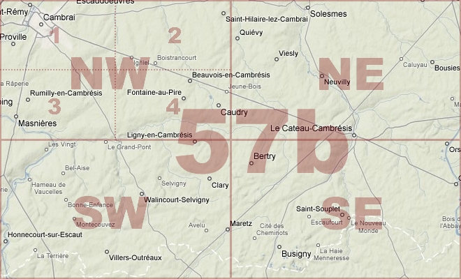
Map Location Diagram
- The Map Location Diagram (right) shows the relative position of places within the area of this grid square.
- Maps having this Map Reference Number will cover the whole area but be less detailed.
- Maps with NE, NW, SE or SW in the Map Reference Number will only cover one-quarter of the whole area but be more detailed.
- Click the following links for more information about How to Read a Map Reference Number or about Map Scale.
Maps for Grid Square 57b
| Link to Image | Map Sheet Number | Scale | Area | Date |
|---|---|---|---|---|
|
433WW1MAP |
51b SE, 51a SW, 57c NE, 57b NW | 1:20,000 | Cambrai | 1918/08 |
|
334WW1MAP |
51b SE, 51a SW, 57c NE, 57b NW (parts) | 1:20,000 | Cambrai | 1918/09 |
|
PC0813WW1MAP |
57b | 1:100,000 | Cambrai | 1917/09 |
|
PC0814WW1MAP |
57b | 1:100,000 | Cambrai | 1917/09 |
|
PC0815WW1MAP |
57b | 1:100,000 | Cambrai | 1917/09 |
|
PC0816WW1MAP |
57b | 1:100,000 | Cambrai | 1917/09 |
|
388WW1MAP |
57b | 1:40,000 | Cambrai | 1917/05 |
|
174WW1MAP |
57b | 1:40,000 | Cambrai | 1917/12 |
|
52WW1MAP |
57b | 1:40,000 | Cambrai | 1918/09 |
|
92WW1MAP |
57b NE | 1:20,000 | Le Cateau | 1918/09 |
|
93WW1MAP |
57b NE | 1:20,000 | Le Cateau | 1918/09 |
|
PC0359WW1MAP |
57b NW | 1:20,000 | Cambrai - Masnieres | 1915/00 |
|
PC0360WW1MAP |
57b NW | 1:20,000 | Cambrai - Masnieres | 1917/03 |
|
350WW1MAP |
57b NW | 1:20,000 | Cambrai | 1918/08 |
|
PC0361WW1MAP |
57b NW | 1:20,000 | Cambrai - Masnieres | 1918/09 |
|
PC0132WW1MAP |
57b NW3 | 1:10,000 | south of Cambrai | 1917/11 |
|
94WW1MAP |
57b SE | 1:20,000 | Albert | 1918/09 |
|
PC0368WW1MAP |
57b SE | 1:20,000 | Berty - St.Souplet | 1918/09 |
|
PC0860WW1MAP |
57b SE | 1:20,000 | Berty - St. Souplet | 1918/09 |
|
73WW1MAP |
57b SE | 1:20,000 | Albert | 1916 |
|
89WW1MAP |
57b SW | 1:20,000 | Walincourt | 1917/04 |
|
PC0362WW1MAP |
57b SW | 1:20,000 | Banteux - Bantouzelle | 1917/06 |
|
PC0364WW1MAP |
57b SW | 1:20,000 | Banteux - Bantouzelle | 1918/02 |
|
56WW1MAP |
57b SW | 1:20,000 | Walincourt | 1918/08 |
|
PC0365WW1MAP |
57b SW | 1:20,000 | Banteux - Bantouzelle | 1918/08 |
|
208WW1MAP |
57b SW | 1:20,000 | Walincourt | 1918/04 |
|
PC0366WW1MAP |
57b SW | 1:20,000 | Banteux - Bantouzelle | 1918/09 |
|
168WW1MAP |
57b SW, 57b SE, 57c NW, 57c NE | 1:10,000 | Queant | 1917/05 |
|
435WW1MAP |
57c NE, SE, 57b NW, SW | 1:20,000 | Gouzeaucourt | |
|
192WW1MAP |
57c SE, 57b SW, 62c NE, 62b NW (parts) | 1:20,000 | Wiancourt | 1918/09 |
|
152WW1MAP |
57c SE, 57b SW, 62c NE, 62b NW (parts) | 1:20,000 | St. Emilie |
AERIAL PHOTOGRAPHS FOR GRID SQUARE 57b
There are no aerial photographs in our collection for this area
Contact: mapref@mcmaster.ca