RESULTS FOR GRID SQUARE 51b
MAPS FOR GRID SQUARE 51b
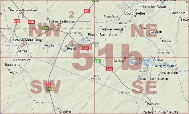
Map Location Diagram
- The Map Location Diagram (right) shows the relative position of places within the area of this grid square.
- Maps having this Map Reference Number will cover the whole area but be less detailed.
- Maps with NE, NW, SE or SW in the Map Reference Number will only cover one-quarter of the whole area but be more detailed.
- Click the following links for more information about How to Read a Map Reference Number or about Map Scale.
Maps for Grid Square 51b
| Link to Image | Map Sheet Number | Scale | Area | Date |
|---|---|---|---|---|
|
PC0663WW1MAP |
36c SW & 51b NW (Parts of) | 1:20,000 | Souchez - Anzin St. Aubin | 1916 |
|
PC0664WW1MAP |
36c SW & 51b NW (Parts of) | 1:20,000 | Souchez - Anzin St. Aubin | 1916 |
|
PC0665WW1MAP |
36c SW & 51b NW (Parts of) | 1:20,000 | Souchez - Anzin St. Aubin | 1916 |
|
PC0666WW1MAP |
36c SW & 51b NW (Parts of) | 1:20,000 | Souchez - Anzin St. Aubin | 1916 |
|
PC0667WW1MAP |
36c SW & 51b NW (Parts of) | 1:20,000 | Souchez - Anzin St. Aubin | 1916 |
|
383WW1MAP |
51b | 1:40,000 | Arras | 1917/10 |
|
384WW1MAP |
51b | 1:40,000 | Arras | 1917/03 |
|
46WW1MAP |
51b | 1:40,000 | Arras | 1917/04 |
|
47WW1MAP |
51b | 1:40,000 | Arras | 1917/04 |
|
62WW1MAP |
51b | 1:40,000 | Arras | 1917/10 |
|
PC0340WW1MAP |
51b SW | 1:20,000 | Achicourt - Boiry Ste. Rictrude | 1917/03 |
|
PC0336WW1MAP |
51b NE | 1:20,000 | Quiery la Motte - Canal de la Sensee | 1917/04 |
|
PC0337WW1MAP |
51b NE | 1:20,000 | Quiery la Motte - Canal de la Sansee | 1918/02 |
|
PC0338WW1MAP |
51b NE | 1:20,000 | Quiery la Motte - Canal de la Sansee | 1918/08 |
|
359WW1MAP |
51b NE | 1:20,000 | Vitry-En-Artois | 1918/09 |
|
88WW1MAP |
51b NE | 1:20,000 | Vitry-En-Artois | 1918 |
|
64WW1MAP |
51b NW | 1:20,000 | Arras | 1918/01 |
|
63WW1MAP |
51b NW | 1:20,000 | Arras | 1918/01 |
|
PC0333WW1MAP |
51b NW | 1:20,000 | Neuville St.Vaast - Ecurie | 1918/07 |
|
PC0328WW1MAP |
51b NW | 1:20,000 | Neuville St.Vaast - Ecurie | 1916/00 |
|
013WW1MAP |
51b NW | 1:20,000 | Arras | 1917/01 |
|
PC0329WW1MAP |
51b NW | 1:20,000 | Neuville St.Vaast - Ecurie | 1917/01 |
|
PC0330WW1MAP |
51b NW | 1:20,000 | Neuville St.Vaast - Ecurie | 1917/01 |
|
PC0331WW1MAP |
51b NW | 1:20,000 | Neuville St.Vaast - Ecurie | 1917/03 |
|
PC0332WW1MAP |
51b NW | 1:20,000 | Neuville St.Vaast - Ecurie | 1917/06 |
|
360WW1MAP |
51b NW | 1:20,000 | Arras | 1917/10 |
|
PC0668WW1MAP |
51b NW & 51b SW (Parts of) | 1:20,000 | Arras - Boiry-Becquerelle | 1916 |
|
PC0669WW1MAP |
51b NW & 51b SW (Parts of) | 1:20,000 | Arras - Boiry-Becquerelle | 1916 |
|
PC0670WW1MAP |
51b NW & 51b SW (Parts of) | 1:20,000 | Arras - Boiry-Becquerelle | 1916 |
|
PC0671WW1MAP |
51b NW & 51b SW (Parts of) | 1:20,000 | Arras - Boiry-Becquerelle | 1916 |
|
PC0099WW1MAP |
51b NW1 | 1:10,000 | Vimy Ridge | 1916/00 |
|
PC0100WW1MAP |
51b NW1 | 1:10,000 | Vimy Ridge | 1916/00 |
|
PC0101WW1MAP |
51b NW1 | 1:10,000 | Vimy Ridge | 1916/00 |
|
336WW1MAP |
51b NW1 | 1:10,000 | Thelus | 1917/03 |
|
PC0102WW1MAP |
51b NW1 | 1:10,000 | Vimy Ridge | 1917/03 |
|
PC0103WW1MAP |
51b NW1 | 1:10,000 | Vimy Ridge | 03/1917 |
|
PC0104WW1MAP |
51b NW1 | 1:10,000 | La Targette - Roclincourt | 1917/03 |
|
PC0559WW1MAP |
51b NW2 | 1:10,000 | Arleux-en-Gohelle - Fresnes-les-Montauban | 1918/02 |
|
PC0105WW1MAP |
51b NW2 | 1:10,000 | Arleux-en-Gochelle - Gloster Wood | 1917/07 |
|
PC0107WW1MAP |
51b NW2 | 1:10,000 | Arleux-en-Gochelle - Gloster Wood | 1918/07 |
|
PC0108WW1MAP |
51b NW2 | 1:10,000 | Arleux-en-Gochelle - Gloster Wood | 1918/07 |
|
PC0109WW1MAP |
51b NW3 | 1:10,000 | Anzin St. Aubin - Achicourt | 1916/00 |
|
PC0502WW1MAP |
51b NW3 | 1:5,000 | R.Scarpe - Oil Factory - St. Laurent Blangy | |
|
PC0110WW1MAP |
51b NW3 | 1:10,000 | Anzin St. Aubin - Achicourt | 1916/00 |
|
118WW1MAP |
51b NW3 | 1:10,000 | Arras | 1917/01 |
|
119WW1MAP |
51b NW3 | 1:10,000 | Arras | 1917/03 |
|
136WW1MAP |
51b NW3 | 1:10,000 | Arras | 1917/03 |
|
PC0111WW1MAP |
51b NW3 | 1:10,000 | Anzin St. Aubin - Achicourt | 1917/03 |
|
PC0504WW1MAP |
51b NW3 & 51b NW4 | 1:5,000 | Athies & area to north & east | |
|
PC0347WW1MAP |
51b SE | 1:20,000 | Eterpigny - Cagnicourt | 1917/02 |
|
9WW1MAP |
51b SE | 1:20,000 | Epinoy | 1917/04 |
|
PC0348WW1MAP |
51b SE | 1:20,000 | Eterpigny - Cagnicourt | 1917/04 |
|
PC0349WW1MAP |
51b SE | 1:20,000 | Arras - Cagnicourt | |
|
PC0350WW1MAP |
51b SE | 1:20,000 | Arras - Cagnicourt | 1918/08 |
|
358WW1MAP |
51b SE | 1:20,000 | Epinoy | 1918/09 |
|
433WW1MAP |
51b SE, 51a SW, 57c NE, 57b NW | 1:20,000 | Cambrai | 1918/08 |
|
334WW1MAP |
51b SE, 51a SW, 57c NE, 57b NW (parts) | 1:20,000 | Cambrai | 1918/09 |
|
337WW1MAP |
51b SE, 57c NE (parts) | 1:20,000 | Bourlon | 1918/09 |
|
PC0125WW1MAP |
51b SE3 | 1:10,000 | east of Bullecourt | 1917/10 |
|
PC0126WW1MAP |
51b SE4 | 1:10,000 | Arras - Cambrai | 1917/07 |
|
96WW1MAP |
51b SW | 1:20,000 | Beaurains | 1916 |
|
PC0339WW1MAP |
51b SW | 1:20,000 | Achicourt - Boiry Ste. Rictrude | 1917/01 |
|
75WW1MAP |
51b SW | 1:20,000 | Beaurains | 1917/03 |
|
PC0341WW1MAP |
51b SW | 1:20,000 | Achicourt - Boiry Ste. Rictrude | 1917/03 |
|
PC0342WW1MAP |
51b SW | 1:20,000 | Achicourt - Boiry Ste. Rictrude | 1917/03 |
|
11WW1MAP |
51b SW | 1:20,000 | Beaurains | 1917/06 |
|
PC0343WW1MAP |
51b SW | 1:20,000 | Achicourt - Boiry Ste. Rictrude | 1917/06 |
|
50WW1MAP |
51b SW | 1:20,000 | Beaurains | 1918/05 |
|
361WW1MAP |
51b SW | 1:20,000 | Beaurains | 1918/04 |
|
PC0344WW1MAP |
51b SW | 1:20,000 | Achicourt - Boiry Ste. Rictrude | 1918/07 |
|
PC0345WW1MAP |
51b SW | 1:20,000 | Achicourt - Boiry Ste. Rictrude | 1918/05 |
|
PC0346WW1MAP |
51b SW & 51b SE | 1:20,000 | Monchy-le-Preux - Fontaine-les-Croisilles | |
|
PC0608WW1MAP |
51b SW and 57c NW | 1:10,000 | Fontaine-lez-Croisilles - Riencourt-lez-Cagnicourt | |
|
PC0608WW1MAP |
51b SW and 57c NW | 1:10,000 | Fontaine-lez-Croisilles - Riencourt-lez-Cagnicourt | |
|
166WW1MAP |
51b SW, 51b SE, 57c NW, 57c NE | 1:20,000 | Hendecourt | 1917/09 |
|
PC0357WW1MAP |
51b SW/51c SE/57d NE/57c NW [composite - parts of] | 1:20,000 | Bailleulmont - Pommier | |
|
PC0112WW1MAP |
51b SW1 | 1:10,000 | Achicourt - St Martin sur Cojeul | 1916/00 |
|
PC0113WW1MAP |
51b SW1 | 1:10,000 | Achicourt - St Martin sur Cojeul | 1917/01 |
|
PC0114WW1MAP |
51b SW1 | 1:10,000 | Achicourt - St Martin sur Cojeul | 1917/01 |
|
112WW1MAP |
51b SW1 | 1:10,000 | Beaurains | 1917/03 |
|
PC0115WW1MAP |
51b SW1 | 1:10,000 | Achicourt - St Martin sur Cojeul | 1917/03 |
|
PC0560WW1MAP |
51b SW2 | 1:10,000 | Willerval North - Fresnes-les-Montauban | 1918/08 |
|
113WW1MAP |
51b SW2 | 1:10,000 | Cherisy | 1917/03 |
|
PC0116WW1MAP |
51b SW2 | 1:10,000 | Monchy-le-Preux - Cherisy | 1917/03 |
|
PC0117WW1MAP |
51b SW2 | 1:10,000 | Monchy-le-Preux - Cherisy | 1917/07 |
|
PC0118WW1MAP |
51b SW2 | 1:10,000 | Monchy-le-Preux - Cherisy | 1918/05 |
|
153WW1MAP |
51b SW2, 51b SW4 (parts) | 1:10,000 | Cherisy | |
|
154WW1MAP |
51b SW2, 51b SW4 (parts) | 1:10,000 | Cherisy | |
|
189WW1MAP |
51b SW2, 51b SW4 (parts) | 1:10,000 | Cherisy | 1917/05 |
|
PC0119WW1MAP |
51b SW3 | 1:10,000 | Boisleux au Mont Henin sur Cojeul - St. Leger | 1917/01 |
|
PC0120WW1MAP |
51b SW3 | 1:10,000 | Boisleux au Mont - St. Leger | 1917/03 |
|
PC0121WW1MAP |
51b SW3 | 1:10,000 | Boisleux au Mont - St. Leger | 1918/05 |
|
PC0122WW1MAP |
51b SW3 & 4 | 1:10,000 | Boisleux - Bullecourt | 1916/00 |
|
107WW1MAP |
51b SW4 | 1:10,000 | Bullecourt | 1917/03 |
|
114WW1MAP |
51b SW4 | 1:10,000 | Bullecourt | 1917/07 |
|
PC0123WW1MAP |
51b SW4 | 1:10,000 | Fontaine-lez-Croisilles - St.Leger | 1917/07 |
|
PC0124WW1MAP |
51b SW4 | 1:10,000 | Fontaine-lez-Croisilles - St.Leger | 1917/09 |
|
PC0738WW1MAP |
51b and 57c | 1:40,000 | 1917/03 | |
|
65WW1MAP |
51bNW | 1:20,000 | Arras | 1918/07 |
|
PC0127WW1MAP |
51c SE & 51bSW | 1:10,000 | Wailly - Boisleux-au-Mont | 1916/00 |
|
PC0609WW1MAP |
Part of 51b SW | 1:10,000 | Guemappe - Riencourt-lez-Cagnicourt | 1917/09 |
|
PC0609WW1MAP |
Part of 51b SW | 1:10,000 | Guemappe - Riencourt-lez-Cagnicourt | 1917/09 |
|
PC0690WW1MAP |
Parts of 51b SW, SW, & 57c NW, NE | 1:20,000 | Wancourt - Moeuvres | |
|
PC0691WW1MAP |
Parts of 51b SW, SW, & 57c NW, NE | 1:20,000 | Wancourt - Moeuvres | |
|
PC0701WW1MAP |
Parts of square 51b NW & NE | 1:20,000 | Arleux-en-Gohelle - Tortequenne | |
|
PC0702WW1MAP |
Parts of squares 51b NW, NE and SW, SE | 1:20,000 | R. Scarpe - Tortequenne |
AERIAL PHOTOGRAPHS FOR GRID SQUARE 51b
Aerial Photograph Location Diagram
- Consult the lettered grid (below) in conjuction with the place names on the map location diagram (lower right) to determine which lettered squares cover your area of interest.
- Choose aerial photos in the table below which have those letters directly following the grid square number.
- Click the following link for more information on How to Read an Aerial Photograph Number.
Map Location Diagram

Aerial Photographs for Grid Square 51b
| Link to Image | Map Reference Number | Area | Year | Month | Day |
|---|---|---|---|---|---|
|
543WW1AIR |
51b.E.8.c. | Inchy-en-Artois. | 1918 | 9 | 12 |
|
547WW1AIR |
51b.Q.15.b. | Arleux; Palleul; Canal du Nord. | 1918 | 9 | 20 |
|
548WW1AIR |
51b.Q.17.b. | Pelleul; Canal du Nord. | 1918 | 9 | 20 |
|
549WW1AIR |
51b.Q.23.a. | Bois-de Quesnoy; Canal du Nord | 1918 | 9 | 20 |
|
557WW1AIR |
51b.Q.23.b. | Bois-de-Quesnoy; Oisy-le-Verger. | 1918 | 9 | 20 |
|
552WW1AIR |
51b.Q.23.b. | Oisy-le-Verger; Canal du Nord. | 1918 | 9 | 20 |
|
553WW1AIR |
51b.Q.30.a. | Oisy-le-Verger. | 1918 | 9 | 20 |
|
551WW1AIR |
51b.Q.30.a. | Oisy-le-Verger; Canal du Nord. | 1918 | 9 | 20 |
|
550WW1AIR |
51b.Q.30.a. | Sauchy-Cauchy; Canal du Nord. | 1918 | 9 | 20 |
|
558WW1AIR |
51b.Q.35.a. | Sauchy-Cauchy; Cemetery Wood. | 1918 | 9 | 20 |
|
537WW1AIR |
51b.W.10.16. | 1918 | 9 | 25 | |
|
538WW1AIR |
51b.W.16. | 1918 | 8 | 25 | |
|
536WW1AIR |
51b.W.16.22. | 1918 | 9 | 25 | |
|
534WW1AIR |
51b.W.22. | 1918 | 9 | 25 | |
|
546WW1AIR |
51b.W.26.27.57c.E.1.2. | Inchy-en-Artois; Canal du Nord; Sains. | 1918 | 9 | 3 |
|
541WW1AIR |
51b.W.26.27.57c.E.1.2. | Sains; Paviland Wood. | 1918 | 9 | 3 |
|
533WW1AIR |
51b.W.28.29. | 1918 | 9 | 25 | |
|
556WW1AIR |
51b.W.5.a. | Sauchy-Lestree | 1918 | 9 | 20 |
|
555WW1AIR |
51b.W.5.a. | Sauchy-Lestree | 1918 | 9 | 20 |
|
554WW1AIR |
51b.W.5.a. | Sauchy-Lestree. | 1918 | 9 | 20 |
|
535WW1AIR |
51b.W.9.10.15.16. | 1918 | 9 | 25 |
Contact: mapref@mcmaster.ca