RESULTS FOR GRID SQUARE 51a
MAPS FOR GRID SQUARE 51a
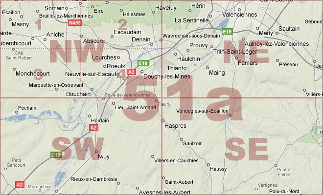
Map Location Diagram
- The Map Location Diagram (right) shows the relative position of places within the area of this grid square.
- Maps having this Map Reference Number will cover the whole area but be less detailed.
- Maps with NE, NW, SE or SW in the Map Reference Number will only cover one-quarter of the whole area but be more detailed.
- Click the following links for more information about How to Read a Map Reference Number or about Map Scale.
Maps for Grid Square 51a
| Link to Image | Map Sheet Number | Scale | Area | Date |
|---|---|---|---|---|
|
60WW1MAP |
51a | 1:40,000 | Valenciennes | 1918/01 |
|
214WW1MAP |
51a | 1:40,000 | Valenciennes | 1918/09 |
|
41WW1MAP |
51a | 1:40,000 | Valenciennes | 1918/09 |
|
382WW1MAP |
51a | 1:40,000 | Valenciennes | 1918/09 |
|
368WW1MAP |
51a NE | 1:20,000 | Valenciennes | 1918/10 |
|
PC0323WW1MAP |
51a NE | 1:20,000 | Ballaing - Wavrechain | 1918/10 |
|
355WW1MAP |
51a NW | 1:20,000 | Denain | 1918/09 |
|
PC0633WW1MAP |
51a NW, NE, SW, SE (Parts of) | 1:20,000 | Escaudain - Parquiaux | 1918/10 |
|
356WW1MAP |
51a SE | 1:20,000 | Bermerain | 1918/09 |
|
PC0325WW1MAP |
51a SE | 1:20,000 | Haspres - St.Albert | 1918/09 |
|
PC0326WW1MAP |
51a SE | 1:20,000 | Haspres - St.Albert | |
|
PC0327WW1MAP |
51a SE | 1:20,000 | Sommaing - Haussy | |
|
PC0863WW1MAP |
51a SE | 1:20,000 | Haspres - St.Albert | |
|
357WW1MAP |
51a SW | 1:20,000 | Iwuy | 1918/08 |
|
78WW1MAP |
51a SW | 1:20,000 | Iwuy | 1918/09 |
|
PC0324WW1MAP |
51a SW | 1:20,000 | Paillencourt - Naves | 1918/10 |
|
433WW1MAP |
51b SE, 51a SW, 57c NE, 57b NW | 1:20,000 | Cambrai | 1918/08 |
|
334WW1MAP |
51b SE, 51a SW, 57c NE, 57b NW (parts) | 1:20,000 | Cambrai | 1918/09 |
AERIAL PHOTOGRAPHS FOR GRID SQUARE 51a
There are no aerial photographs in our collection for this area
Contact: mapref@mcmaster.ca