RESULTS FOR GRID SQUARE 44
MAPS FOR GRID SQUARE 44
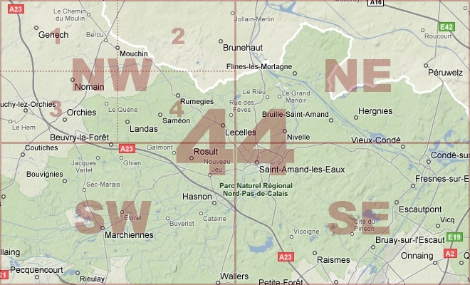
Map Location Diagram
- The Map Location Diagram (right) shows the relative position of places within the area of this grid square.
- Maps having this Map Reference Number will cover the whole area but be less detailed.
- Maps with NE, NW, SE or SW in the Map Reference Number will only cover one-quarter of the whole area but be more detailed.
- Click the following links for more information about How to Read a Map Reference Number or about Map Scale.
Maps for Grid Square 44
| Link to Image | Map Sheet Number | Scale | Area | Date |
|---|---|---|---|---|
|
PC0299WW1MAP |
36 SW & 36c (44a) NW | 1:20,000 | Neuve Chapelle - Richebourg | 1918/00 |
|
PC0291WW1MAP |
36b(44b) NE | 1:20,000 | Allouagne - Bruay | 1918/05 |
|
PC0314WW1MAP |
37 SW 37 SE 44 NE (parts of ) | 1:20,000 | Froidmont - Buyelle | 1916/00 |
|
451WW1MAP |
44 | 1:40,000 | St. Amand | 1917/05 |
|
377WW1MAP |
44 | 1:40,000 | St. Amand | 1918/09 |
|
364WW1MAP |
44 NE | 1:20,000 | Peruwelz | 1918/10 |
|
PC0319WW1MAP |
44 NE | 1:20,000 | Hollain - Bleharies | 1918/10 |
|
365WW1MAP |
44 NW | 1:20,000 | Orchies | 1918/10 |
|
PC0318WW1MAP |
44 NW | 1:20,000 | Genech - Auchy | 1917/10 |
|
366WW1MAP |
44 SE | 1:20,000 | St. Amand-Ies Eaux | 1918/10 |
|
367WW1MAP |
44 SW | 1:20,000 | Marchiennes Ville | 1918/10 |
|
PC0320WW1MAP |
44 SW | 1:20,000 | Coutiches - Cattelet | 1918/10 |
|
PC0301WW1MAP |
44a (36c) NE | 1:20,000 | Gondecourt - Phalempin | 1918/07 |
|
PC0300WW1MAP |
44a (36c) NW | 1:20,000 | Le Plantin (Festubert) - Hill 70 | |
|
PC0309WW1MAP |
44a (36c) SE | 1:20,000 | Ostricourt - Dourges | 1918/06 |
|
PC0310WW1MAP |
44a (36c) SE | 1:20,000 | Ostricourt - Dourges | 1918/09 |
|
67WW1MAP |
44a NW | 1:20,000 | Loos | 1918/06 |
|
PC0289WW1MAP |
44b(36b) NE | 1:20,000 | Allouagne - Bruay | 1918/01 |
|
PC0294WW1MAP |
44b(36b) SE | UNKNOWN | Beugin - Villers-Brulin | 1918/05 |
|
378WW1MAP |
44c | 1:40,000 | Fressin | 1918/07 |
|
254WW1MAP |
I.D. No. 44 | 1:750,000 | Handeni | 1916/07 |
|
PC0842WW1MAP |
Parts of 29, 37, 44, 51, 57, 62b, 66c, 70d | 1:250,000 | SE England Ramsgate - Le Treport | 1918/05 |
|
PC0695WW1MAP |
[Parts of 36b(44b) SW, 44c SE, 51c NW, 51d NE] | 1:20,000 | Siracourt - Moncheaux | 1917 |
AERIAL PHOTOGRAPHS FOR GRID SQUARE 44
There are no aerial photographs in our collection for this area
Contact: mapref@mcmaster.ca