RESULTS FOR GRID SQUARE 36b
MAPS FOR GRID SQUARE 36b
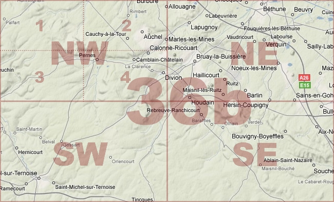
Map Location Diagram
- The Map Location Diagram (right) shows the relative position of places within the area of this grid square.
- Maps having this Map Reference Number will cover the whole area but be less detailed.
- Maps with NE, NW, SE or SW in the Map Reference Number will only cover one-quarter of the whole area but be more detailed.
- Click the following links for more information about How to Read a Map Reference Number or about Map Scale.
Maps for Grid Square 36b
| Link to Image | Map Sheet Number | Scale | Area | Date |
|---|---|---|---|---|
|
212WW1MAP |
36a SE, 36 SW, 36b NE, 36a NW (parts) | 1:40,000 | Bethune | |
|
14WW1MAP |
36a SE, 36 SW, 36b NE, 36c NW (parts) | 1:40,000 | Bethune | 1916 |
|
23WW1MAP |
36b | 1:40,000 | Bethune | 1915 |
|
175WW1MAP |
36b | 1:40,000 | Bethune | 1916 |
|
374WW1MAP |
36b | 1:40,000 | Bethune | 1918/01 |
|
PC0541WW1MAP |
36b N | 1:10,000 | Barlin - Noeux-les-Mines | 1917/00 |
|
17WW1MAP |
36b NE | 1:20,000 | Bethune | 1916 |
|
PC0290WW1MAP |
36b NE | 1:20,000 | Allouagne - Bruay | 1918/01 |
|
117WW1MAP |
36b NE2 | 1:10,000 | Bethune | 1916 |
|
PC0073WW1MAP |
36b NE4 | 1:10,000 | Noeux-les-Mines - Hersin | 1916/00 |
|
PC0292WW1MAP |
36b SE | 1:20,000 | Beugin - Villers-Brulin | 1916/00 |
|
PC0293WW1MAP |
36b SE | 1:20,000 | Beugin - Villers-Brulin | 1916/00 |
|
211WW1MAP |
36b SE | 1:20,000 | Freesnicourt | |
|
PC0074WW1MAP |
36b SE4 | 1:10,000 | Gouy - Bois de Berthonval | 1916/00 |
|
PC0075WW1MAP |
36b SE4 & 36c SW3 | 1:10,000 | Notre Dame de Lorette - Bonval Wood | 1916/00 |
|
PC0291WW1MAP |
36b(44b) NE | 1:20,000 | Allouagne - Bruay | 1918/05 |
|
PC0289WW1MAP |
44b(36b) NE | 1:20,000 | Allouagne - Bruay | 1918/01 |
|
PC0294WW1MAP |
44b(36b) SE | UNKNOWN | Beugin - Villers-Brulin | 1918/05 |
|
PC0695WW1MAP |
[Parts of 36b(44b) SW, 44c SE, 51c NW, 51d NE] | 1:20,000 | Siracourt - Moncheaux | 1917 |
AERIAL PHOTOGRAPHS FOR GRID SQUARE 36b
Aerial Photograph Location Diagram
- Consult the lettered grid (below) in conjuction with the place names on the map location diagram (lower right) to determine which lettered squares cover your area of interest.
- Choose aerial photos in the table below which have those letters directly following the grid square number.
- Click the following link for more information on How to Read an Aerial Photograph Number.
Map Location Diagram

Aerial Photographs for Grid Square 36b
| Link to Image | Map Reference Number | Area | Year | Month | Day |
|---|---|---|---|---|---|
|
497WW1AIR |
36b.X.11. | Lens Front. | 1917 | 12 | 3 |
Contact: mapref@mcmaster.ca