RESULTS FOR GRID SQUARE 36a
MAPS FOR GRID SQUARE 36a
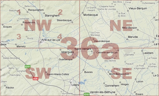
Map Location Diagram
- The Map Location Diagram (right) shows the relative position of places within the area of this grid square.
- Maps having this Map Reference Number will cover the whole area but be less detailed.
- Maps with NE, NW, SE or SW in the Map Reference Number will only cover one-quarter of the whole area but be more detailed.
- Click the following links for more information about How to Read a Map Reference Number or about Map Scale.
Maps for Grid Square 36a
| Link to Image | Map Sheet Number | Scale | Area | Date |
|---|---|---|---|---|
|
248WW1MAP |
27,28 & 36a (parts) | 1:40,000 | Bailleul | 1918/04 |
|
12WW1MAP |
36a | 1:40,000 | Bethune | 1917/05 |
|
373WW1MAP |
36a | 1:40,000 | Bethune | 1916 |
|
458WW1MAP |
36a | 1:40,000 | Bruay | |
|
219WW1MAP |
36a | 1:40,000 | Bethune | |
|
444WW1MAP |
36a | 1:10,000 | Swartenbrouch | |
|
PC0279WW1MAP |
36a NE | 1:20,000 | Hazebrouck - Morbecque | 1915/00 |
|
PC0280WW1MAP |
36a NE | 1:20,000 | Hazebrouck - Morbecque | 1915/00 |
|
PC0281WW1MAP |
36a NE | 1:20,000 | Hazebrouck - Morbecque | 1916/00 |
|
PC0282WW1MAP |
36a NE | 1:20,000 | Hazebrouck - Morbecque | 1918/05 |
|
39WW1MAP |
36a NE | 1:20,000 | Merville | 1918/06 |
|
235WW1MAP |
36a NE (part) | 1:20,000 | La Mottee | 1918/04 |
|
PC0274WW1MAP |
36a NW | 1:20,000 | Heuringhen - Clarques | 1915/00 |
|
PC0275WW1MAP |
36a NW | 1:20,000 | Heuringhen - Clarques | 1915/00 |
|
PC0276WW1MAP |
36a NW | 1:20,000 | Heuringhen - Clarques | 1916 |
|
PC0277WW1MAP |
36a NW | 1:20,000 | Heuringhen - Clarques | 1918/04 |
|
PC0285WW1MAP |
36a SE | 1:20,000 | St.Venant - Chocques | 1914-1915/00 |
|
PC0286WW1MAP |
36a SE | 1:20,000 | St.Venant - Chocques | 1917/10 |
|
PC0287WW1MAP |
36a SE | 1:20,000 | St.Venant - Chocques | 1918/07 |
|
PC0288WW1MAP |
36a SE | 1:20,000 | St.Venant - Chocques | 1918/07 |
|
212WW1MAP |
36a SE, 36 SW, 36b NE, 36a NW (parts) | 1:40,000 | Bethune | |
|
14WW1MAP |
36a SE, 36 SW, 36b NE, 36c NW (parts) | 1:40,000 | Bethune | 1916 |
|
PC0616WW1MAP |
36a SE2 | 1:20,000 | Vieille Chapelle | |
|
PC0617WW1MAP |
36a SE2 | 1:20,000 | St. Floris - Gonnehem | |
|
PC0284WW1MAP |
36a SW | 1:20,000 | Blessy - Lillers | 1917/10 |
|
PC0661WW1MAP |
Parts of 27 SW, 27 SE, 36a NW, 36a NE | 1:20,000 | Ebblinghem - Aire | 1917/07 |
|
PC0662WW1MAP |
Parts of 27 SW, 27 SE, 36a NW, 36a NE | 1:20,000 | Ebblinghem - Aire | 1918/07 |
|
PC0736WW1MAP |
Parts of 27,28, 36, 36a | 1:40,000 | Hazewinde - Doulieu | 1918/07 |
|
PC0659WW1MAP |
Parts of 27a SE, 27 SW, 36d NE, 36a NW | 1:20,000 | St. Momelin - Staple | 1918/07 |
|
PC0660WW1MAP |
Parts of 27a SE, 27 SW, 36d NE, 36a NW | 1:20,000 | St. Momelin - Staple | 1918/07 |
AERIAL PHOTOGRAPHS FOR GRID SQUARE 36a
Aerial Photograph Location Diagram
- Consult the lettered grid (below) in conjuction with the place names on the map location diagram (lower right) to determine which lettered squares cover your area of interest.
- Choose aerial photos in the table below which have those letters directly following the grid square number.
- Click the following link for more information on How to Read an Aerial Photograph Number.
Map Location Diagram

Aerial Photographs for Grid Square 36a
| Link to Image | Map Reference Number | Area | Year | Month | Day |
|---|---|---|---|---|---|
|
505WW1AIR |
36a. | Merville Front. | 1918 | 6 | 7 |
|
506WW1AIR |
36a. | Merville Front. | 1917 | 6 | 30 |
|
509WW1AIR |
36a. | Merville Front. | 1918 | 6 | 30 |
|
508WW1AIR |
36a. | Merville Front. | 1918 | 6 | 30 |
|
510WW1AIR |
36a.Q.13.b. | Merville Front; Bethune. | 1918 | 5 | 8 |
|
511WW1AIR |
36a.Q.2.a. | Merville Front; Bethune. | 1917 | 5 | 9 |
|
507WW1AIR |
36a.X.16.d. 05.80. | Merville Front. | 1918 | 6 | 16 |
Contact: mapref@mcmaster.ca