RESULTS FOR GRID SQUARE 36
MAPS FOR GRID SQUARE 36
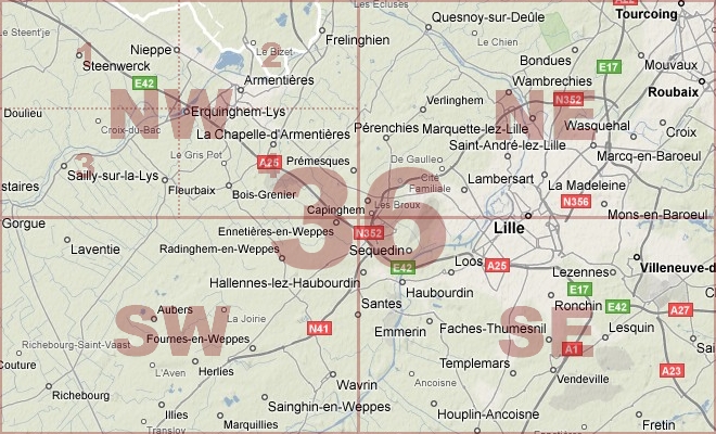
Map Location Diagram
- The Map Location Diagram (right) shows the relative position of places within the area of this grid square.
- Maps having this Map Reference Number will cover the whole area but be less detailed.
- Maps with NE, NW, SE or SW in the Map Reference Number will only cover one-quarter of the whole area but be more detailed.
- Click the following links for more information about How to Read a Map Reference Number or about Map Scale.
Maps for Grid Square 36
| Link to Image | Map Sheet Number | Scale | Area | Date |
|---|---|---|---|---|
|
PC0783WW1MAP |
20, 28, 36 | 1:100,000 | ||
|
248WW1MAP |
27,28 & 36a (parts) | 1:40,000 | Bailleul | 1918/04 |
|
222WW1MAP |
27a & 36d (parts) | 1:40,000 | St. Omer | 1918/08 |
|
PC0836WW1MAP |
36 | 1:250,000 | [Vimy Ridge to the Sea] | |
|
PC0837WW1MAP |
36 | 1:250,000 | [Vimy Ridge to the Sea] | |
|
PC0838WW1MAP |
36 | 1:250,000 | [Vimy Ridge to the Ailette] | |
|
PC0839WW1MAP |
36 | 1:250,000 | [Vimy Ridge to the Ailette] | |
|
318WW1MAP |
36 | 1:40,000 | Lille | 1915 |
|
220WW1MAP |
36 | 1:40,000 | Lille | 1915 |
|
298WW1MAP |
36 | 1:40,000 | Lille | 1918/02 |
|
372WW1MAP |
36 | 1:40,000 | Armentieres | 1916 |
|
253WW1MAP |
36 & 37 (parts) | 1:10,000 | Sartori | 1918/05 |
|
PC0263WW1MAP |
36 NE | 1:20,000 | Quesnoy sur Deule - La Houlette | 1916/00 |
|
PC0264WW1MAP |
36 NE | 1:20,000 | Quesnoy sur Deule - La Houlette | 1917/06 |
|
PC0265WW1MAP |
36 NE | 1:20,000 | Quesnoy sur Deule - La Houlette | 1917/12 |
|
PC0060WW1MAP |
36 NE1 | 1:10,000 | 1917/04 | |
|
132WW1MAP |
36 NE1 | 1:10,000 | Quesnoy | 1917/11 |
|
PC0258WW1MAP |
36 NW | 1:20,000 | Steenwerck - Fleurbaix | 1916/00 |
|
PC0259WW1MAP |
36 NW | 1:20,000 | Steenwerck - Fleurbaix | 1916/00 |
|
PC0260WW1MAP |
36 NW | 1:20,000 | Steenwerck - Fleurbaix | 1917/10 |
|
313WW1MAP |
36 NW | 1:20,000 | Armentieres | 1918/08 |
|
PC0261WW1MAP |
36 NW | 1:20,000 | Steenwerck - Fleurbaix | 1918/09 |
|
PC0261WW1MAP |
36 NW | 1:20,000 | Steenwerck - Fleurbaix | 1918/08 |
|
PC0262WW1MAP |
36 NW | 1:20,000 | Steenwerck - Fleurbaix | 1918/08 |
|
PC0859WW1MAP |
36 NW | 1:20,000 | Steenwerck - Fleurbaix | 1918/08 |
|
PC0053WW1MAP |
36 NW1 | 1:10,000 | la Creche - River Lys | 1918/06 |
|
PC0054WW1MAP |
36 NW2 | 1:10,000 | Armentieres | 1915/00 |
|
PC0054WW1MAP |
36 NW2 | 1:10,000 | Armentieres | 1915/00 |
|
PC0055WW1MAP |
36 NW2 | 1:10,000 | Armentieres | 1915/00 |
|
PC0056WW1MAP |
36 NW2 | 1:10,000 | Le Romarin - lEpinette | 1916/12 |
|
130WW1MAP |
36 NW2 | 1:10,000 | Armentieeres | 1918/04 |
|
PC0057WW1MAP |
36 NW2 & NE1 | 1:10,000 | Le Touquet - Bois de Verlinghem | 1916/00 |
|
PC0058WW1MAP |
36 NW4 | 1:10,000 | Bois Grenier | 1915/00 |
|
PC0059WW1MAP |
36 NW4 | 1:10,000 | Erquinghem - Bois Blancs | 1918/09 |
|
PC0272WW1MAP |
36 SE | 1:20,000 | Haubourdin - Seclin | 1916/00 |
|
PC0273WW1MAP |
36 SE | 1:20,000 | Haubourdin - Seclin | 1917/11 |
|
PC0072WW1MAP |
36 SE3 | 1:10,000 | Seclin | 1918/09 |
|
PC0266WW1MAP |
36 SW | 1:20,000 | Laventie - Illies | 1915/00 |
|
PC0270WW1MAP |
36 SW | 1:20,000 | Laventie - Illies | 1918/07 |
|
66WW1MAP |
36 SW | 1:20,000 | Aubers | 1918/07 |
|
157WW1MAP |
36 SW | 1:20,000 | Neuve Chapelle | 1915 |
|
PC0267WW1MAP |
36 SW | 1:20,000 | Laventie - Illies | 1915/03 |
|
PC0268WW1MAP |
36 SW | 1:20,000 | Laventie - Illies | 1916/00 |
|
PC0269WW1MAP |
36 SW | 1:20,000 | Laventie - Illies | 1916/00 |
|
PC0271WW1MAP |
36 SW & 36 NW (parts) | 1:20,000 | Armentieres - Fromelles | 1918/00 |
|
PC0299WW1MAP |
36 SW & 36c (44a) NW | 1:20,000 | Neuve Chapelle - Richebourg | 1918/00 |
|
PC0495WW1MAP |
36 SW1 | 1:5,000 | 1915/10 | |
|
PC0496WW1MAP |
36 SW1 | 1:5,000 | Aubers - Neuve Chapelle | |
|
PC0500WW1MAP |
36 SW1 | 1:5,000 | Lens Town Centre | |
|
PC0509WW1MAP |
36 SW1 | 1:10,000 | Harlech Castle - Leclercq Fme | 1917/03 |
|
PC0525WW1MAP |
36 SW1 | 1:10,000 | Richebourg lAvoue - Douvrin | 1915/00 |
|
PC0526WW1MAP |
36 SW1 | 1:10,000 | Richebourg lAvoue - Douvrin | 1915/00 |
|
PC0614WW1MAP |
36 SW1 | 1:20,000 | Aubers - Rue Tilleloy | |
|
PC0724WW1MAP |
36 SW1 | 1:40,000 | Neuve Chapelle - Gavrelle | |
|
PC0064WW1MAP |
36 SW1 | 1:10,000 | Le Drumez - Pietre | 1918/07 |
|
PC0063WW1MAP |
36 SW1 | 1:10,000 | Aubers | 1915/00 |
|
121WW1MAP |
36 SW1 | 1:10,000 | Aubers | 1916 |
|
PC0061WW1MAP |
36 SW1 | 1:10,000 | Aubers | 1915/00 |
|
PC0062WW1MAP |
36 SW1 | 1:10,000 | Aubers | 1915/00 |
|
PC0545WW1MAP |
36 SW2 | 1:10,000 | Loos - Cite du Gd. Conde | 1917/07 |
|
PC0546WW1MAP |
36 SW2 | 1:10,000 | Loos - Cite du Gd. Conde | |
|
PC0066WW1MAP |
36 SW2 | 1:10,000 | Le Bridoux - Santes | 07/1918 |
|
PC0065WW1MAP |
36 SW2 | 1:10,000 | Radinghem | 1915/00 |
|
PC0518WW1MAP |
36 SW3 | 1:10,000 | Le Plantin - Richebourg lAvoue | 1915/00 |
|
PC0519WW1MAP |
36 SW3 | 1:10,000 | le Plantin - Richebourg lAvoue | 1915/00 |
|
PC0522WW1MAP |
36 SW3 | 1:10,000 | Route B - Chapelle St Roche | |
|
PC0514WW1MAP |
36 SW3 | 1:10,000 | la Mottelette - Fauquissart | 1915/00 |
|
PC0069WW1MAP |
36 SW3 | 1:10,000 | Richebourg | 1915/00 |
|
122WW1MAP |
36 SW3 | 1:10,000 | Richebourg | 1916 |
|
PC0070WW1MAP |
36 SW3 | 1:10,000 | Richebourg | 1916/00 |
|
PC0071WW1MAP |
36 SW3 | 1:10,000 | Richebourg St. Vaast - Rue de Marais | 1917/08 |
|
PC0071WW1MAP |
36 SW3 | 1:10,000 | Richebourg St. Vaast - Rue de Marais | 1917/08 |
|
PC0067WW1MAP |
36 SW3 | 1:10,000 | Richebourg St. Vaast | 1915/00 |
|
PC0068WW1MAP |
36 SW3 | 1:10,000 | Richebourg | 1915/00 |
|
PC0811WW1MAP |
36, 52, 57 | 1:100,000 | 1917/03 | |
|
49WW1MAP |
36NW | 1:20,000 | Armentieres | 1917/10 |
|
12WW1MAP |
36a | 1:40,000 | Bethune | 1917/05 |
|
373WW1MAP |
36a | 1:40,000 | Bethune | 1916 |
|
458WW1MAP |
36a | 1:40,000 | Bruay | |
|
219WW1MAP |
36a | 1:40,000 | Bethune | |
|
444WW1MAP |
36a | 1:10,000 | Swartenbrouch | |
|
PC0279WW1MAP |
36a NE | 1:20,000 | Hazebrouck - Morbecque | 1915/00 |
|
PC0280WW1MAP |
36a NE | 1:20,000 | Hazebrouck - Morbecque | 1915/00 |
|
PC0281WW1MAP |
36a NE | 1:20,000 | Hazebrouck - Morbecque | 1916/00 |
|
PC0282WW1MAP |
36a NE | 1:20,000 | Hazebrouck - Morbecque | 1918/05 |
|
39WW1MAP |
36a NE | 1:20,000 | Merville | 1918/06 |
|
235WW1MAP |
36a NE (part) | 1:20,000 | La Mottee | 1918/04 |
|
PC0274WW1MAP |
36a NW | 1:20,000 | Heuringhen - Clarques | 1915/00 |
|
PC0275WW1MAP |
36a NW | 1:20,000 | Heuringhen - Clarques | 1915/00 |
|
PC0276WW1MAP |
36a NW | 1:20,000 | Heuringhen - Clarques | 1916 |
|
PC0277WW1MAP |
36a NW | 1:20,000 | Heuringhen - Clarques | 1918/04 |
|
PC0285WW1MAP |
36a SE | 1:20,000 | St.Venant - Chocques | 1914-1915/00 |
|
PC0286WW1MAP |
36a SE | 1:20,000 | St.Venant - Chocques | 1917/10 |
|
PC0287WW1MAP |
36a SE | 1:20,000 | St.Venant - Chocques | 1918/07 |
|
PC0288WW1MAP |
36a SE | 1:20,000 | St.Venant - Chocques | 1918/07 |
|
212WW1MAP |
36a SE, 36 SW, 36b NE, 36a NW (parts) | 1:40,000 | Bethune | |
|
14WW1MAP |
36a SE, 36 SW, 36b NE, 36c NW (parts) | 1:40,000 | Bethune | 1916 |
|
PC0616WW1MAP |
36a SE2 | 1:20,000 | Vieille Chapelle | |
|
PC0617WW1MAP |
36a SE2 | 1:20,000 | St. Floris - Gonnehem | |
|
PC0284WW1MAP |
36a SW | 1:20,000 | Blessy - Lillers | 1917/10 |
|
23WW1MAP |
36b | 1:40,000 | Bethune | 1915 |
|
175WW1MAP |
36b | 1:40,000 | Bethune | 1916 |
|
374WW1MAP |
36b | 1:40,000 | Bethune | 1918/01 |
|
PC0541WW1MAP |
36b N | 1:10,000 | Barlin - Noeux-les-Mines | 1917/00 |
|
17WW1MAP |
36b NE | 1:20,000 | Bethune | 1916 |
|
PC0290WW1MAP |
36b NE | 1:20,000 | Allouagne - Bruay | 1918/01 |
|
117WW1MAP |
36b NE2 | 1:10,000 | Bethune | 1916 |
|
PC0073WW1MAP |
36b NE4 | 1:10,000 | Noeux-les-Mines - Hersin | 1916/00 |
|
PC0292WW1MAP |
36b SE | 1:20,000 | Beugin - Villers-Brulin | 1916/00 |
|
PC0293WW1MAP |
36b SE | 1:20,000 | Beugin - Villers-Brulin | 1916/00 |
|
211WW1MAP |
36b SE | 1:20,000 | Freesnicourt | |
|
PC0074WW1MAP |
36b SE4 | 1:10,000 | Gouy - Bois de Berthonval | 1916/00 |
|
PC0075WW1MAP |
36b SE4 & 36c SW3 | 1:10,000 | Notre Dame de Lorette - Bonval Wood | 1916/00 |
|
PC0291WW1MAP |
36b(44b) NE | 1:20,000 | Allouagne - Bruay | 1918/05 |
|
PC0548WW1MAP |
36c | 1:10,000 | Quarries - Loison | |
|
PC0556WW1MAP |
36c | 1:10,000 | Alec Corons - Bois Bernard | 1918/02 |
|
375WW1MAP |
36c | 1:40,000 | Lens | 1916 |
|
PC0298WW1MAP |
36c NW | 1:20,000 | Le Plantin (Festubert) - Hill 70 | 1917/12 |
|
PC0531WW1MAP |
36c NW | 1:10,000 | Auchy - North of Loos | |
|
PC0530WW1MAP |
36c NW | 1:10,000 | Grafton St - Cite St Elie | |
|
PC0295WW1MAP |
36c NW | 1:20,000 | Le Plantin (Festubert) - Hill 70 | 1916/00 |
|
PC0296WW1MAP |
36c NW | 1:20,000 | Le Plantin (Festubert) - Hill 70 | 1917/04 |
|
PC0297WW1MAP |
36c NW | 1:20,000 | Le Plantin (Festubert) - Hill 70 | 1917/04 |
|
51WW1MAP |
36c NW | 1:20,000 | Loos | 1917/05 |
|
PC0627WW1MAP |
36c NW, 36c SW [Parts of] | 1:20,000 | Brickstacks (Cuinchy) - Lens | |
|
PC0517WW1MAP |
36c NW1 | 1:10,000 | la Bassee - Canteleux | 1915 |
|
133WW1MAP |
36c NW1 | 1:10,000 | La Bassee | 1917/12 |
|
PC0080WW1MAP |
36c NW1 | 1:10,000 | Le Plantin - Hohenzollern Redoubt | 1917/12 |
|
PC0079WW1MAP |
36c NW1 | 1:10,000 | Le Plantin - Hohenzollern Redoubt | 05/1917 |
|
PC0076WW1MAP |
36c NW1 | 1:10,000 | La Bassee | 1915/00 |
|
PC0077WW1MAP |
36c NW1 | 1:10,000 | La Bassee | 1915/00 |
|
PC0078WW1MAP |
36c NW1 | 1:10,000 | La Bassee | 1915/00 |
|
PC0081WW1MAP |
36c NW2 | 1:10,000 | 1918/06 | |
|
PC0538WW1MAP |
36c NW3 | 1:10,000 | E side of Hill 70 - Bois des Dames | |
|
PC0539WW1MAP |
36c NW3 | 1:10,000 | S of Hulluch - outskirts of Lens | |
|
135WW1MAP |
36c NW3 | 1:10,000 | Loos | 1917/05 |
|
PC0082WW1MAP |
36c NW3 & NW1 (Part) | 1:10,000 | Loos | 1915/00 |
|
PC0083WW1MAP |
36c NW3 & NW1 (Part) | 1:10,000 | Loos | 1915/00 |
|
PC0084WW1MAP |
36c NW3 & NW1 (Part) | 1:10,000 | Loos | 1915/00 |
|
PC0085WW1MAP |
36c NW3 & NW1, 2 & 4 (Parts) | 1:10,000 | Loos | 1915/00 |
|
PC0086WW1MAP |
36c NW3 & NW1, 2 & 4 (Parts) | 1:10,000 | Loos | 1915 |
|
PC0542WW1MAP |
36c NW3, 36c NW4 | 1:10,000 | Bois Hugo - Harnes Fosses | 1918/08 |
|
131WW1MAP |
36c NW3, 36c SW1 (both) | 1:10,000 | Loos/Lens | 1916 |
|
PC0087WW1MAP |
36c NW4 | 1:10,000 | German Area East of Loos | 1917/05 |
|
PC0547WW1MAP |
36c SW | 1:10,000 | Chalk Pit Wood - Cite du Gd. Conde | |
|
PC0553WW1MAP |
36c SW | 1:20,000 | Foose 12 de Lens - Cite St. Anthoine | 1917/08 |
|
PC0553WW1MAP |
36c SW | 1:20,000 | Foose 12 de Lens - Cite St. Anthoine | 1917/08 |
|
362WW1MAP |
36c SW | 1:20,000 | Lens | 1917/06 |
|
43WW1MAP |
36c SW | 1:20,000 | Lens | 1917/07 |
|
PC0307WW1MAP |
36c SW | 1:20,000 | Grenay - Souchez | 1917/07 |
|
363WW1MAP |
36c SW | 1:20,000 | Lens | 1917/12 |
|
468WW1MAP |
36c SW | 1:20,000 | Lens | 1917/12 |
|
PC0552WW1MAP |
36c SW | 1:20,000 | Cite St. Laurent - Sallaumines | 1917/09 |
|
PC0303WW1MAP |
36c SW | 1:20,000 | Grenay - Souchez | 1916/00 |
|
PC0302WW1MAP |
36c SW | 1:20,000 | Grenay - Souchez | 1916/00 |
|
PC0304WW1MAP |
36c SW | 1:20,000 | Grenay - Souchez | 1916/00 |
|
42WW1MAP |
36c SW | 1:20,000 | Lens | 1917/02 |
|
PC0305WW1MAP |
36c SW | 1:20,000 | Grenay - Souchez | 1917/02 |
|
PC0306WW1MAP |
36c SW | 1:20,000 | Grenay - Souchez | 1917/02 |
|
PC0663WW1MAP |
36c SW & 51b NW (Parts of) | 1:20,000 | Souchez - Anzin St. Aubin | 1916 |
|
PC0664WW1MAP |
36c SW & 51b NW (Parts of) | 1:20,000 | Souchez - Anzin St. Aubin | 1916 |
|
PC0665WW1MAP |
36c SW & 51b NW (Parts of) | 1:20,000 | Souchez - Anzin St. Aubin | 1916 |
|
PC0666WW1MAP |
36c SW & 51b NW (Parts of) | 1:20,000 | Souchez - Anzin St. Aubin | 1916 |
|
PC0667WW1MAP |
36c SW & 51b NW (Parts of) | 1:20,000 | Souchez - Anzin St. Aubin | 1916 |
|
PC0501WW1MAP |
36c SW1 | 1:5,000 | Angres - Givenchy-en-Gohelle | |
|
PC0554WW1MAP |
36c SW1 | 1:10,000 | Lens - Fosse 2 de Drocourt | 1918/03 |
|
PC0555WW1MAP |
36c SW1 | 1:10,000 | Lens - Mericourt | 1918/08 |
|
PC0634WW1MAP |
36c SW1 | 1:20,000 | Vimy Ridge | 1917/03 |
|
PC0091WW1MAP |
36c SW1 | 1:10,000 | Loos Crassier - Avion | 1917/11 |
|
PC0551WW1MAP |
36c SW1 | 1:10,000 | Cite St. Laurent - Sallaumines | 1917/09 |
|
PC0089WW1MAP |
36c SW1 | 1:10,000 | Loos Crassier - Avion | 1916/00 |
|
120WW1MAP |
36c SW1 | 1:10,000 | Lens | 1916 |
|
123WW1MAP |
36c SW1 | 1:10,000 | Lens | 1917/02 |
|
PC0090WW1MAP |
36c SW1 | 1:10,000 | Loos Crassier - Avion | 1917/02 |
|
PC0088WW1MAP |
36c SW1 | 1:10,000 | Lens | 1915/00 |
|
PC0543WW1MAP |
36c SW2 | 1:10,000 | Posen Locality - Loison | 1918/02 |
|
PC0544WW1MAP |
36c SW2 | 1:10,000 | Posen Locality - Loison | 1918/02 |
|
PC0092WW1MAP |
36c SW2 | 1:10,000 | East of Lens | 1917/07 |
|
PC0523WW1MAP |
36c SW3 | UNKNOWN | Givenchy - Hohenzollern Redoubt | |
|
PC0096WW1MAP |
36c SW3 | 1:10,000 | Vimy Ridge | 1918/05 |
|
109WW1MAP |
36c SW3 | 1:10,000 | Vimy | 1916 |
|
PC0094WW1MAP |
36c SW3 | 1:10,000 | Vimy Ridge | 1917/02 |
|
PC0095WW1MAP |
36c SW3 | 1:10,000 | Vimy Ridge | 1917/07 |
|
PC0093WW1MAP |
36c SW3 | 1:10,000 | Vimy Ridge | 1915/00 |
|
PC0557WW1MAP |
36c SW4 | 1:10,000 | Alec Corons - Bois Bernard | 1917/12 |
|
PC0097WW1MAP |
36c SW4 | 1:10,000 | Mericourt - Bois-en-T | 1917/12 |
|
PC0098WW1MAP |
36c SW4 | 1:10,000 | Mericourt - Bois-en-T | 1918/05 |
|
PC0516WW1MAP |
36cNW1 | 1:10,000 | la Bassee - Canteleux | 1915/00 |
|
PC0301WW1MAP |
44a (36c) NE | 1:20,000 | Gondecourt - Phalempin | 1918/07 |
|
PC0300WW1MAP |
44a (36c) NW | 1:20,000 | Le Plantin (Festubert) - Hill 70 | |
|
PC0309WW1MAP |
44a (36c) SE | 1:20,000 | Ostricourt - Dourges | 1918/06 |
|
PC0310WW1MAP |
44a (36c) SE | 1:20,000 | Ostricourt - Dourges | 1918/09 |
|
PC0289WW1MAP |
44b(36b) NE | 1:20,000 | Allouagne - Bruay | 1918/01 |
|
PC0294WW1MAP |
44b(36b) SE | UNKNOWN | Beugin - Villers-Brulin | 1918/05 |
|
266WW1MAP |
North H-36/ O-II | 1:125,000 | Suez | 1913 |
|
PC0789WW1MAP |
Part of Sheet 28 and 36 | 1:100,000 | Bergues - Lille | 1917/10 |
|
PC0521WW1MAP |
Part of Sheet 36 | 1:10,000 | Richebourg St. Vaast - Fosse 8 | 1916/00 |
|
PC0571WW1MAP |
Part of Sheet 36 | 1:10,000 | Armentieres - Fort de Senarmont | 1915/00 |
|
PC0572WW1MAP |
Part of Sheet 36 | 1:10,000 | Armentieres - Fort de Senarmont | 1915/00 |
|
PC0615WW1MAP |
Part of Sheet 36 | 1:20,000 | St. Floris - Gonnehem | 1918/04 |
|
PC0619WW1MAP |
Part of Sheet 36 | 1:20,000 | Mauquissart - Mad Point | |
|
PC0620WW1MAP |
Part of Sheet 36 | 1:20,000 | Vendin-lez-Bethune - Fosse 7 | |
|
PC0621WW1MAP |
Part of Sheet 36 | 1:20,000 | Richebourg - Epinoy | |
|
PC0622WW1MAP |
Part of Sheet 36 | 1:20,000 | ||
|
PC0623WW1MAP |
Part of Sheet 36 | 1:20,000 | Richebourg - Epinoy | |
|
PC0624WW1MAP |
Part of Sheet 36 | 1:20,000 | Auchy - Annay | |
|
PC0625WW1MAP |
Part of Sheet 36 | 1:20,000 | Auchy - Annay | |
|
PC0626WW1MAP |
Part of Sheet 36 | 1:20,000 | Chalk Pit Wood - Fosse 2 de Drocourt | |
|
PC0628WW1MAP |
Part of Sheet 36 | 1:20,000 | Chalk Pit Wood - Rouvroy | |
|
PC0632WW1MAP |
Part of Sheet 36 | 1:20,000 | Bracquement - Acheville | |
|
PC0636WW1MAP |
Part of Sheet 36 | 1:20,000 | Angres - le Point du Jour | 1917/03 |
|
PC0649WW1MAP |
Part of Sheet 36 | 1:20,000 | Southern Edge of Ploegsteert Wood - La Houliette | 1915 |
|
PC0723WW1MAP |
Part of Sheet 36 | 1:40,000 | Chocques - La Bassee | 1918/04 |
|
PC0726WW1MAP |
Part of Sheet 36 | 1:40,000 | Arques - Bruay | |
|
PC0727WW1MAP |
Part of Sheet 36 | 1:40,000 | Mont Kemmel - Wingles | |
|
PC0733WW1MAP |
Part of Sheet 36 | 1:40,000 | Henneveux - Coyecque | 1918/05 |
|
PC0754WW1MAP |
Part of Sheet 36 | 1:80,000 | Watten - La Bassee | 1914 |
|
PC0765WW1MAP |
Part of Sheet 36 | 1:100,000 | 1915 | |
|
PC0775WW1MAP |
Part of Sheet 36 | 1:100,000 | Arques - Arras | 1918/04 |
|
PC0790WW1MAP |
Part of Sheet 36 | 1:100,000 | Dixmude - Armentieres | 1918/02 |
|
PC0791WW1MAP |
Part of Sheet 36 | 1:100,000 | Bergues - Laventie | 1918/03 |
|
PC0794WW1MAP |
Part of Sheet 36 | 1:100,000 | Calais - Fromelles | 1918/08 |
|
PC0795WW1MAP |
Part of Sheet 36 | 1:100,000 | Calais - Fromelles | 1918/04 |
|
PC0796WW1MAP |
Part of Sheet 36 | 1:100,000 | Calais - Fromelles | 1918/04 |
|
PC0804WW1MAP |
Part of Sheet 36 | 1:100,000 | Calais - Auchy | 1918/07 |
|
PC0805WW1MAP |
Part of Sheet 36 | 1:100,000 | Calais - Auchy | 1918/07 |
|
PC0806WW1MAP |
Part of Sheet 36 | 1:100,000 | Calais - Auchy | 1918/07 |
|
PC0817WW1MAP |
Part of Sheet 36 | 1:100,000 | Montreuil-sur-Mer - Flesselles | 1918/06 |
|
PC0618WW1MAP |
Part of Sheet 36 | 1:20,000 | St. Floris - Gonnehem | |
|
PC0629WW1MAP |
Part of Sheet 36 | 1:20,000 | Loos - Beaumont | 1917/10 |
|
PC0630WW1MAP |
Part of Sheet 36 | 1:20,000 | Loos - Beaumont | |
|
PC0828WW1MAP |
Part of Sheet 36 | 1:100,000 | 1918/10 | |
|
PC0631WW1MAP |
Part of Sheet 36 | 1:20,000 | Loos - Beaumont | |
|
PC0769WW1MAP |
Part of Sheet 36 | 1:100,000 | Lumbres - North Arras | |
|
PC0770WW1MAP |
Part of Sheet 36 | 1:100,000 | Lumbres - North Arras | |
|
PC0771WW1MAP |
Part of Sheet 36 | 1:100,000 | Lumbres - North Arras | |
|
PC0772WW1MAP |
Part of Sheet 36 | 1:100,000 | Lumbres - North Arras | |
|
PC0773WW1MAP |
Part of Sheet 36 | 1:100,000 | Lumbres - North Arras | |
|
PC0774WW1MAP |
Part of Sheet 36 | 1:100,000 | Lumbres - North Arras | |
|
PC0777WW1MAP |
Part of Sheet 36 | 1:100,000 | Montreuil-sur-Mer - Cambrai | |
|
PC0776WW1MAP |
Part of Shhet 36 | 1:100,000 | Montreuil-sur-Mer - Arras | |
|
PC0661WW1MAP |
Parts of 27 SW, 27 SE, 36a NW, 36a NE | 1:20,000 | Ebblinghem - Aire | 1917/07 |
|
PC0662WW1MAP |
Parts of 27 SW, 27 SE, 36a NW, 36a NE | 1:20,000 | Ebblinghem - Aire | 1918/07 |
|
PC0736WW1MAP |
Parts of 27,28, 36, 36a | 1:40,000 | Hazewinde - Doulieu | 1918/07 |
|
PC0659WW1MAP |
Parts of 27a SE, 27 SW, 36d NE, 36a NW | 1:20,000 | St. Momelin - Staple | 1918/07 |
|
PC0660WW1MAP |
Parts of 27a SE, 27 SW, 36d NE, 36a NW | 1:20,000 | St. Momelin - Staple | 1918/07 |
|
PC0510WW1MAP |
Parts of 36 NW3 & 4, 36 SW1, 2 & 4 | 1:10,000 | Croix Blanche - la Basse Boulogne | 1916/00 |
|
PC0822WW1MAP |
Parts of Sheets 27 and 36 | 1:100,000 | Bergues - Laventie | 1918/01 |
|
PC0792WW1MAP |
Parts of Sheets 28 and 36 | 1:100,000 | Ypres - Bethune | 1918/04 |
|
PC0800WW1MAP |
Parts of Sheets 28 and 36 | 1:100,000 | Coast at Bray Dunes - Estaires | 1918/05 |
|
PC0801WW1MAP |
Parts of Sheets 28 and 36 | 1:100,000 | Coast Dunkerque to Bray Dunes - Estaires | 1918/06 |
|
PC0802WW1MAP |
Parts of Sheets 28 and 36 | 1:100,000 | Coast Dunkerque to Bray Dunes - Estaires | 1918/06 |
|
PC0803WW1MAP |
Parts of Sheets 28 and 36 | 1:100,000 | Coast Dunkerque to Bray Dunes - Estaires | 1918/06 |
|
PC0799WW1MAP |
Parts of Sheets 28, 29, 36 | 1:100,000 | St Omer - Armentieres | 1918/01 |
|
PC0778WW1MAP |
Parts of Sheets 36 and 51 | 1:100,000 | Armentieres - Denain | 1917/03 |
|
PC0780WW1MAP |
Parts of Sheets 36 and 57 | 1:100,000 | Richebourg St Vaast - Cambrai | |
|
PC0781WW1MAP |
Parts of Sheets 36 and 57 | 1:100,000 | Richebourg St Vaast - Cambrai | |
|
PC0782WW1MAP |
Parts of Sheets 36 and 57 | 1:100,000 | Richebourg St Vaast - Cambrai | |
|
PC0511WW1MAP |
Portion of 36 SW3 | 1:10,000 | Richebourg St. Vaast - Lorgies | 1916/00 |
|
PC0513WW1MAP |
Portion of Sheet 36c NW1 | 1:10,000 | Cuinchy - Hohenzollern Redoubt | 1916/00 |
|
PC0512WW1MAP |
Portions of 36 SW3 & 36c NW1 | 1:10,000 | Indian Village - Beau Puits | 1916/00 |
|
PC0540WW1MAP |
Portions of 36c NW1,2,3 & 4 | 1:10,000 | Les Baraques - Annay | |
|
267WW1MAP |
South A-36/ F | 1:250,000 | Lumbwa | 1916 |
|
PC0695WW1MAP |
[Parts of 36b(44b) SW, 44c SE, 51c NW, 51d NE] | 1:20,000 | Siracourt - Moncheaux | 1917 |
AERIAL PHOTOGRAPHS FOR GRID SQUARE 36
Aerial Photograph Location Diagram
- Consult the lettered grid (below) in conjuction with the place names on the map location diagram (lower right) to determine which lettered squares cover your area of interest.
- Choose aerial photos in the table below which have those letters directly following the grid square number.
- Click the following link for more information on How to Read an Aerial Photograph Number.
Map Location Diagram

Aerial Photographs for Grid Square 36
| Link to Image | Map Reference Number | Area | Year | Month | Day |
|---|---|---|---|---|---|
|
201WW1AIR |
36.C.29c.I.5b. | Houplines. | 1917 | 4 | 24 |
|
202WW1AIR |
36.F.28.L.4. | Roubaix. | 1917 | 2 | 5 |
|
208WW1AIR |
36.F.29.30.L.5.6. | Roubaix. | 1917 | 2 | 5 |
|
214WW1AIR |
36.F.3.4. | Tourcoing. | 1917 | 2 | 2 |
|
203WW1AIR |
36.K.12.18a.b. | Lille. | 1917 | 5 | 1 |
|
210WW1AIR |
36.K.25.26.31.32.33.P.6.12.Q.1.2.7.8. | Lille citadelle. | 1917 | 6 | 22 |
|
216WW1AIR |
36.K.26.27.32.33. | Lille citadelle. | 1916 | 4 | 24 |
|
209WW1AIR |
36.K.30. | Lille | 1917 | 2 | 1 |
|
215WW1AIR |
36.K.31b.d.32a.c. | Lille citadelle. | 1917 | 5 | 7 |
|
206WW1AIR |
36.K.5.6.11.12.17.18.L.1a.c.7a.c.13a.c. | Lille | 1917 | 11 | 12 |
|
204WW1AIR |
36.K.L.N.E.LILLE. | Lille | 1917 | 7 | 13 |
|
211WW1AIR |
36.Q.10.16. | Lille; Le Maroc. | 1917 | 5 | 12 |
|
207WW1AIR |
36.Q.13.14.15.19.20.21.25.26.27.31.32.33. | Lille; Faubourg des Postes. | 1917 | 7 | 22 |
|
212WW1AIR |
36.Q.14.15. | Lille. | 1917 | 5 | 12 |
|
213WW1AIR |
36.Q.9.10a.c.15a.b.16a. | Lille | 1916 | 9 | 25 |
Contact: mapref@mcmaster.ca