RESULTS FOR GRID SQUARE 29
MAPS FOR GRID SQUARE 29
Map Location Diagram
- The Map Location Diagram (right) shows the relative position of places within the area of this grid square.
- Maps having this Map Reference Number will cover the whole area but be less detailed.
- Maps with NE, NW, SE or SW in the Map Reference Number will only cover one-quarter of the whole area but be more detailed.
- Click the following links for more information about How to Read a Map Reference Number or about Map Scale.
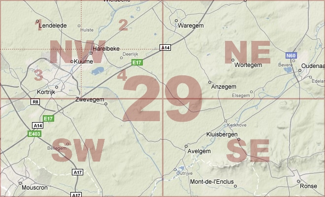
Maps for Grid Square 29
| Link to Image | Map Sheet Number | Scale | Area | Date |
|---|---|---|---|---|
|
321WW1MAP |
29 | 1:40,000 | Courtrai | 1917/05 |
|
439WW1MAP |
29 | 1:20,000 | Berchem | |
|
441WW1MAP |
29 | 1:40,000 | Courtrai | |
|
238WW1MAP |
29 (part) | 1:40,000 | Tenhoves | 1918/08 |
|
PC0255WW1MAP |
29 NE | 1:20,000 | Vive-Saint Eloi - Anseghem | 1918/10 |
|
317WW1MAP |
29 NW | 1:20,000 | Courtrai | 1918/09 |
|
PC0254WW1MAP |
29 NW | 1:20,000 | Boschmolens - Gulleghem | 1918/09 |
|
323WW1MAP |
29 SE | 1:20,000 | Renaix | 1918/10 |
|
PC0257WW1MAP |
29 SW | 1:20,000 | Wevelghem - Mouscron | 1918/09 |
|
PC0256WW1MAP |
29 SW | 1:20,000 | Wevelghem - Mouscron | 1914/00 |
|
287WW1MAP |
29 [xxix Blatt] | 1:20,000 | Renaix | |
|
PC0842WW1MAP |
Parts of 29, 37, 44, 51, 57, 62b, 66c, 70d | 1:250,000 | SE England Ramsgate - Le Treport | 1918/05 |
|
PC0799WW1MAP |
Parts of Sheets 28, 29, 36 | 1:100,000 | St Omer - Armentieres | 1918/01 |
AERIAL PHOTOGRAPHS FOR GRID SQUARE 29
Aerial Photograph Location Diagram
- Consult the lettered grid (below) in conjuction with the place names on the map location diagram (lower right) to determine which lettered squares cover your area of interest.
- Choose aerial photos in the table below which have those letters directly following the grid square number.
- Click the following link for more information on How to Read an Aerial Photograph Number.
Map Location Diagram

Aerial Photographs for Grid Square 29
| Link to Image | Map Reference Number | Area | Year | Month | Day |
|---|---|---|---|---|---|
|
365WW1AIR |
29.J.28.29. | 1918 | 10 | 30 | |
|
366WW1AIR |
29.J.28.35. | 1918 | 10 | 30 | |
|
368WW1AIR |
29.J.30.35. | 1918 | 10 | 30 | |
|
359WW1AIR |
29.J.36.K.31. | 1918 | 10 | 30 | |
|
358WW1AIR |
29.K.31. | 1918 | 10 | 30 | |
|
357WW1AIR |
29.K.31.32. | 1918 | 10 | 30 | |
|
367WW1AIR |
29.K.32.Q.1.2. | 1918 | 10 | 30 | |
|
349WW1AIR |
29.P.22.b.d. | 1918 | 10 | 30 | |
|
348WW1AIR |
29.P.22b.d. | 1918 | 10 | 30 | |
|
347WW1AIR |
29.P.29a.b. | 1918 | 10 | 30 | |
|
342WW1AIR |
29.P.29a.d.Q | 1918 | 10 | 30 | |
|
345WW1AIR |
29.P.29d.Q.25a. | 1918 | 10 | 30 | |
|
343WW1AIR |
29.P.36c.V. | 1918 | 10 | 30 | |
|
364WW1AIR |
29.Q.1.2. | 1918 | 10 | 30 | |
|
360WW1AIR |
29.Q.28. | 1918 | 10 | 30 | |
|
362WW1AIR |
29.Q.7.8. | 1918 | 10 | 30 | |
|
361WW1AIR |
29.Q.7.8. | 1918 | 10 | 30 | |
|
363WW1AIR |
29.Q.8. | 1918 | 10 | 30 | |
|
350WW1AIR |
29.V.9b. | Escanaffles church | 1918 | 10 | 30 |
Contact: mapref@mcmaster.ca